Krefeld, Germany
| Krefeld | ||
|---|---|---|

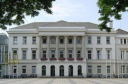
City Hall
|
||
|
||
| Coordinates: 51°20′0″N 06°34′0″E / 51.33333°N 6.56667°ECoordinates: 51°20′0″N 06°34′0″E / 51.33333°N 6.56667°E | ||
| Country | Germany | |
| State | North Rhine-Westphalia | |
| Admin. region | Düsseldorf | |
| District | Urban districts of Germany | |
| Government | ||
| • Lord Mayor | Frank Meyer (SPD) | |
| Area | ||
| • Total | 137.68 km2 (53.16 sq mi) | |
| Elevation | 39 m (128 ft) | |
| Population (2015-12-31) | ||
| • Total | 225,144 | |
| • Density | 1,600/km2 (4,200/sq mi) | |
| Time zone | CET/CEST (UTC+1/+2) | |
| Postal codes | 47701-47839 | |
| Dialling codes | 02151 | |
| Vehicle registration | KR | |
| Website | www.krefeld.de | |
Krefeld (German pronunciation: [ˈkʁeːfɛlt]), also known as Crefeld until 1929, is a city in North Rhine-Westphalia, Germany. It is located northwest of Düsseldorf, its centre lying just a few kilometres to the west of the River Rhine; the borough of Uerdingen is situated directly on the Rhine. Krefeld is accessed by the autobahns A57 (Cologne–Nijmegen) and the A44 (Aachen–Düsseldorf–Dortmund–Kassel).
Krefeld is also called the "Velvet and Silk City".
Krefeld's residents speak Hochdeutsch, the standard German taught to all people in Germany. However, the native dialect is a Low German variety, sometimes locally called Krefelder Plattdeutsch, Krieewelsch Platt, Plattdeutsch, or sometimes simply Platt. The Uerdingen line isogloss, separating general dialectical areas in Germany and neighbouring Germanic-speaking countries, runs through and is named after Krefeld's Uerdingen district, originally an independent municipality.
The town originated in Roman times when the legions founded the military camp of Gelduba (today the borough of Gellep). Records first mention Krefeld itself in 1105 under the name of Krinvelde. Uerdingen, originally an independent town east of Krefeld, founded in 1255, became in medieval times larger and more important than Krefeld.
...
Wikipedia


