Kostanay Region
|
Kostanay Region Қостанай облысы Костанайская область |
||
|---|---|---|
| Region | ||

The old building of the region library, Kostanay
|
||
|
||
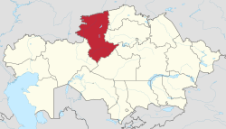
 Map of Kazakhstan, location of Kostanay Province highlighted |
||
| Coordinates: 53°12′N 63°38′E / 53.200°N 63.633°ECoordinates: 53°12′N 63°38′E / 53.200°N 63.633°E | ||
| Country |
|
|
| Established | 1936 | |
| Capital | Kostanay | |
| Government | ||
| • Akim | Archimedes Mukhambetov | |
| Area | ||
| • Total | 196,001 km2 (75,676 sq mi) | |
| Population (2015-10-01) | ||
| • Total | 882,961 | |
| • Density | 4.5/km2 (12/sq mi) | |
| Time zone | East (UTC+6) | |
| • Summer (DST) | not observed (UTC+6) | |
| Postal codes | 110000 | |
| Area codes | +7 (714) | |
| ISO 3166 code | KZ-KUS | |
| Vehicle registration | 10, P | |
| Districts | 16 | |
| Cities | 5 | |
| Townships | 8 | |
| Villages | 255 | |
| Website | www |
|
Kostanay Region (Kazakh: Қостанай облысы, Qostanay oblısı, قوستاناي وبلىسى) is a region of Kazakhstan. Its administrative center is the city of Kostanay. The population of the region is 900,300. The population living in Kostanay is 207,000 which is equivalent to 23% of the region.
Kostanay Region is adjacent to the Russian federal subjects Orenburg Oblast, Chelyabinsk Oblast, Kurgan Oblast, and is near the Ural Mountains. It also touches four other Kazakh regions: Aktobe Region to the southwest, Karaganda Region to the south, Akmola Region to the southeast, and North Kazakhstan Region to the northeast. The Tobol (Tobyl) River, a tributary of the Irtysh River, starts in and flows through the region on its way to Russia. Kostanay Region's area is 197,000 square kilometers, making it the sixth largest of the Kazakh regions.
Resources of an animal and flora of Kostanay Region are suitable for the organization and development of zones and objects of civilized fishery and a hunt, lake-commodity fish culture, hunt facilities development. The fauna of ground animal includes 52 kinds of mammal, 267 is constant or temporarily living birds, 10 kinds of amphibious and kowtowing, in reservoirs 24 kinds of fishes live.
Naurzum reserve (877 km²), 3 natural sanctuaries (1630 km²) and 12 state nature sanctuaries (0.47 km²) with a rich vegetative cover are pride of region.
The territory of region is characterized by rather flat relief with inflows of the rivers: Ayat, Ubagan, Ui, Torgai with inflows of the rivers: Saryozen, Kara. The Northern part occupy southeast suburb of the West-Siberian lowland, to the south from it is situated Torgai plateau; in the west - wavy plain Zaural plateau and in a southwest Saryarka spurs. River network is rare. Within the limits of the region it is totaled about 310 fine rivers. The largest rivers - Tobol and Torgai. On the river Tobol are Verhnetobolsk, Karatomar and Amangeldy water basins. In Kostanay Region are more than 5 thousand lakes. Largest of them are located in Torgai dell - Kusmyryn, Sarymoin, Aksuat, Sarykopa. Woodland area 2,175 km² including 1,512 km² natural plantings. In connection with the Soviet Virgin Lands Campaign, much of the area was ploughed for wheat. The Kostanay Region is rich in minerals, especially iron ore (deposits of magnetite ores - Sokolovsk, Sarbaiskoe, Kachary and brown soolits iron ores - Ayatsk iron ore pool, Lisakovsk deposit). The total stock of magnetite's ores and hematite's makes 15,7 billion tons, of them easy enrich and not demanding enrichment - 5,7 billion tons. Especially bowels are rich in iron ore, brown coal, asbestos, fire-resistant and brick clay, flux and cement limestone, glass sand, a building stone and others. Opened 19 deposits of bauxite, 7 - gold, on one of silver and nickel. In northern part of area chernozems and pine forests (Arakaragai, Amankaragai) prevail; in the central part - chestnut ground with pine forest Naurzimkaragai on the basis of which the same reserve is organized; the southern part is dominated by grasslands and shrublands.
...
Wikipedia

