Korso
| Korso | |
|---|---|
| City District | |
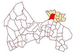
 Location on the map of Vantaa, with the district in red and the major region in light brown |
|
| Coordinates: 60°21′03″N 25°04′40″E / 60.35083°N 25.07778°ECoordinates: 60°21′03″N 25°04′40″E / 60.35083°N 25.07778°E | |
| Country |
|
| City |
|
| Major region | Korso |
| Area | |
| • Total | 3.0 km2 (1.2 sq mi) |
| • Major region | 19.5 km2 (7.5 sq mi) |
| Population (1.1.2014) | |
| • Total | 7,402 |
| • Density | 2,500/km2 (6,400/sq mi) |
| • Major region | 29,765 |
| • Major region density | 1,500/km2 (4,000/sq mi) |
| Time zone | GMT +2 |
| Postal Code(s) | 01450, 01451 |
| Website | www |
Korso is a district and major region in northeastern Vantaa, Finland. The district has 7,402 inhabitants (as of 1 January 2014).
Since 2007, the Korso major region has included the following nine districts: Matari, Korso, Mikkola, Metsola, Leppäkorpi, Jokivarsi, Nikinmäki, Vierumäki and Vallinoja. The Korso major region has a total 29,765 inhabitants (as of 1 January 2014).
Korso is located to the west of the main north-south track line of the Finnish railways. The nearest city is Kerava, six kilometres to the north.
According to the Vantaa neighbourhood division, Korso is bordered by the railway tracks to the east, by Vallinoja to the north and by Vierumäki to the northwest.
The name Korso was born when the crossing point of the borders of three villages - Ali-Kerava and Hyrylä in Tuusula as well as Hanaböle in the old parish of Helsinki - was marked by a cross on the highest cliff of Korso (the word "cross" is kors in Swedish and the word "border" is rå; thus the name originally meant "cross border"). There is a memorial plaque about the history of Korso near the Ruusuvuori school.
At the end of the 19th century, an overtake point was needed on the main railway track line halfway between Tikkurila and Kerava. The Korso stop was built in 1889 in nearly uninhabited wilderness at the border of Tuusula and the Helsinki parish - Korso. The train started to stop at Korso twice a day, which provided a starting point for the development of the area. The current disused station building was built in 1938 according to Thure Hellström's class V station plans for the Seinäjoki-Kristiinankaupunki-Kaskinen railway track line.
When Kerava was separated from Tuusula as a market town in 1924, the area of the old Ali-Kerava village was included wholly in it. It also included the Korso railway station, whose neighbourhood formed a clearly separate residential point from the centre of the market town. The area grew quickly especially after the wars, and in the 1950s, Korso was the largest connected separate-home-based residential area in Finland. Factories, such as Sokeva owned by the Central Organisation for the Hard of Sight, were also founded in Korso.
...
Wikipedia
