Komorowice, Bielsko-Biała
| Komorowice | |
|---|---|
| District of Bielsko-Biała | |

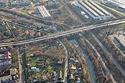
Biała River in the southern part of Komorowice
|
|
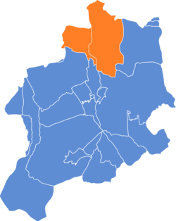
 Location of Komorowice within Bielsko-Biała |
|
| Coordinates: 49°51′16″N 19°2′26″E / 49.85444°N 19.04056°ECoordinates: 49°51′16″N 19°2′26″E / 49.85444°N 19.04056°E | |
| Country |
|
| Voivodeship | Silesian |
| County/City | Bielsko-Biała |
| Area | |
| • Total | 15.3117 km2 (5.9119 sq mi) |
| Population (2006) | |
| • Total | 10,112 |
| • Density | 660/km2 (1,700/sq mi) |
| Time zone | CET (UTC+1) |
| • Summer (DST) | CEST (UTC+2) |
| Area code(s) | (+48) 033 |
Komorowice (German: Batzdorf) is the northernmost part of Bielsko-Biała, Silesian Voivodeship, southern Poland. It is located on both banks of the Biała River, the historical border river between Silesia and Lesser Poland, and from the mid-15th century to 1772, also the states of Poland and Bohemia (from 1526 part of the Habsburg Monarchy).
Komorowice is an informal dzielnica (a form of district). Since 2002 it consists of two osiedla (auxiliary units, Polish: jednostki pomocnicze), which have a combined area of 15.3117 km2 (Komorowice Krakowskie: 9.6152 km2, Komorowice Śląskie: 5.6995 km2) and on December 31, 2006 had altogether 10,112 inhabitants (7,778 in Komorowice Krakowskie, 2,334 in Komorowice Śląskie).
The name of the village is derived from personal name Komor locally meaning also a mosquito (Polish: , German: , hence Mückendorf).
The village was established in the late 13th century as part of a larger settlement campaign taking place on the territory of what would later be known as Upper Silesia. Actually two settlements were established. Both were first mentioned in a Latin document of Diocese of Wrocław called Liber fundationis episcopatus Vratislaviensis from around 1305 as item in Bertoltowitz and item in Muthindorf. It meant that the villages were still in the early process of location (the size of land to pay a tithe from was not yet precise). They were both located on the Biała River, with Bertoltowitz in the south and Muthindorf in the north. Muthindorf ( meaning a village in German) was undoubtedly settled by Germans, whereas in case of Bertoltowitz an ethnic German named Bertold was either its founder or the first owner, but the majority of denizens of the village were of Polish (Slavic) origin, as a typical Slavic ending -itz (later -ice) was used in the name of the settlement. In 1314 or 1315 in the process of feudal fragmentation of Poland the Duchy of Oświęcim was split from the Duchy of Teschen with the new border running along Biała River and cutting through the villages, dividing them into two parts.
...
Wikipedia
