Koktebel
|
Koktebel Коктебель Köktöbel |
|
|---|---|
 |
|
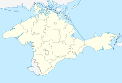
| Location of Koktebel within Crimea | |
| Coordinates: 44°57′36″N 35°14′26″E / 44.96000°N 35.24056°ECoordinates: 44°57′36″N 35°14′26″E / 44.96000°N 35.24056°E | |
| Country | Russia/Ukraine |
| Republic | Crimea |
| Municipality | Feodosia Municipality |
| Area | |
| • Total | 0.8169 km2 (0.3154 sq mi) |
| Elevation | 30 m (100 ft) |
| Population (2014) | |
| • Total | 2,807 |
| • Density | 3,477.8/km2 (9,007/sq mi) |
| Time zone | MSK (UTC+4) |
| Postal code | 98186 |
| Area code(s) | +380-6562 |
| Former name | Planerskoye (1945 - 1991) |
| Climate | Cfa |
Koktebel (Ukrainian: Коктебéль, Russian: Коктебéль, Crimean Tatar: Köktöbel), formerly known as Planerskoye, is an urban-type settlement and one of the most popular resort townlets in South-Eastern Crimea. Koktebel is situated on the shore of the Black Sea about halfway between Feodosia and Sudak and is subordinated to the Feodosia Municipality. Population: 2,807 (2014 Census).
It is best known for its literary associations. The Russian poet Maximilian Voloshin made it his residence, where he entertained many distinguished guests, including Marina Tsvetayeva, Osip Mandelshtam, and Andrey Bely (who died there). They all wrote remarkable poems in Koktebel. Another prominent literary resident of Koktebel was Ilya Ehrenburg who lived there circa 1919 while escaping from anti-Semitic riots in Kiev
The name Köktöbel is of Turkic origin: in Crimean Tatar it means “Land of the blue hills” (from kök, “sky blue”, and töbe, “hill” or “mountain”, composed with the collective suffix -el). Its Soviet name of Planerskoye comes from the Russian planer, or glider: the hills above the shoreline were the site of many early experiments in manned heavier-than-air flight by Russian pioneer aviators. The local airfield is still known as Planerskoye.
...
Wikipedia

