Kok River
| Kok River (แม่น้ำกก) | |
|
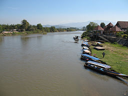
The Kok River in Amphoe Mae Ai, Chiang Mai Province
|
|
| Countries | Burma, Thailand |
|---|---|
| States | Shan State, Chiang Mai Province, Chiang Rai Province |
| Districts | Mae Ai, Mueang Chiang Rai, Mae Chan, Wiang Chai, Chiang Saen |
| Tributaries | |
| - right | Fang, Lao River |
| City | Chiang Rai city |
| Source | |
| - location | Daen Lao Range, Shan State, Burma |
| Mouth | Mekong River |
| - location | Sop Kok, Wiang Chai, Chiang Rai Province |
| - elevation | 358 m (1,175 ft) |
| - coordinates | 20°14′39″N 100°8′19″E / 20.24417°N 100.13861°ECoordinates: 20°14′39″N 100°8′19″E / 20.24417°N 100.13861°E |
| Length | 285 km (177 mi) |
| Basin | 10,875 km2 (4,199 sq mi) |
| Discharge | for Chiang Rai city |
| - average | 120 m3/s (4,238 cu ft/s) |
| - max | 848 m3/s (29,947 cu ft/s) |
| - min | 5 m3/s (177 cu ft/s) |
|
Map of the Thai highlands
|
|
The Kok River (Thai: แม่น้ำกก, rtgs: Maenam Kok, Thai pronunciation: [mɛ̂ːnáːm kòk]) flows in Southeast Asia.
The river originates in the Daen Lao Range, Shan State, Burma. It flows eastwards across the Myanmar-Thailand border, coming in at the Thai border town of Tha Ton (Thai: ท่าตอน, also spelled Thaton ). It flows to Mae Ai district, Chiang Mai Province. Most of its length in Thailand is in Chiang Rai Province where it passes Mueang Chiang Rai District after which it bends northeastwards and flows through Mae Chan, Wiang Chai and Chiang Saen districts.
It is a wide, shallow, and slow-moving river. There is about 600 metres (2,000 ft) of small-scale whitewater halfway between the towns of Taton and Chiang Rai. Alongside the Mae Kok river, an hour's boat ride upstream from Chiang Rai town, is a touristy "elephant camp" on its north shore.
For several kilometres downriver from Chiang Rai, the river becomes a lake, until it reaches the irrigation dam near Wiang Chai.
The Kok River is a tributary of the Mekong River, with its mouth at Sop Kok in Chiang Saen district, opposite the Lao border.
...
Wikipedia


