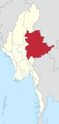
Shan State
|
Shan State ရှမ်းပြည်နယ် |
||
|---|---|---|
| State | ||
| Myanma transcription(s) | ||
| • Burmese | hram: prany nai | |
|
||
 Location of Shan State in Myanmar |
||
| Coordinates: 21°30′N 98°0′E / 21.500°N 98.000°ECoordinates: 21°30′N 98°0′E / 21.500°N 98.000°E | ||
| Country |
|
|
| Region | East central | |
| Capital | Taunggyi | |
| Government | ||
| • Chief Minister | Lin Htut (NLD) | |
| • Legislature | Shan State Hluttaw | |
| Area | ||
| • Total | 155,801.3 km2 (60,155.2 sq mi) | |
| Area rank | 1st | |
| Population (2014) | ||
| • Total | 5,824,432 | |
| • Rank | 4th | |
| • Density | 37/km2 (97/sq mi) | |
| Demographics | ||
| • Ethnicities | Shan, Bamar, Han-Chinese, Wa, Lisu, Danu, Intha, Lahu, Ta'ang, Pa-O, Taungyo, Indians, Gurkha | |
| • Religions | Buddhism, Christianity, Islam, Hinduism | |
| Time zone | MST (UTC+06:30) | |
| Website | www |
|
Shan State (ရှမ်းပြည်နယ်, pronounced: [ʃáɴ pjìnɛ̀]; Shan: မိူင်းတႆး [mə́ŋ.táj]) is a state of Myanmar. Shan State borders China to the north, Laos to the east, and Thailand to the south, and five administrative divisions of Burma in the west. Largest of the 14 administrative divisions by land area, Shan State covers 155,800 km², almost a quarter of the total area of Burma. The state gets its name from the Shan people, one of several ethnic groups that inhabit the area. Shan State is largely rural, with only three cities of significant size: Lashio, Kengtung, and the capital, Taunggyi. Taungyyi is 150.7 km north east of the nation's capital Naypyitaw.
Shan State, with many ethnic groups, is home to several armed ethnic armies. While the military government has signed ceasefire agreements with most groups, vast areas of the state, especially those east of the Thanlwin river, remain outside the central government's control, and in recent years have come under heavy ethnic-Chinese economic and political influence. Other areas are under the control of military groups such as the Shan State Army.
...
Wikipedia

