Koh-i Baba
| Koh-i-Baba | |
|---|---|

|
|
| Highest point | |
| Elevation | 4,951 m (16,243 ft) |
| Coordinates | 34°38′43″N 67°37′27″E / 34.64528°N 67.62417°ECoordinates: 34°38′43″N 67°37′27″E / 34.64528°N 67.62417°E |
| Geography | |
|
|
|
| Location | Bamyan Province, Afghanistan |
| Parent range | Hindu Kush, Mountains, Afghanistan, |
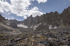
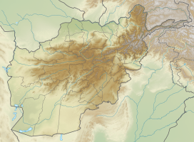
The Baba Mountain range (Pashto: بابا غر Bâbâ Ǧar; Persian: کوه بابا Koh-e Bâbâ) is the western extension of the Hindu Kush, and the origin of Afghanistan's Kabul, Helmand, Arghandab and the Hari rivers. The mountain range is crowned by Foladi peak (Shah Fuladi, 34°38′43″N 67°37′27″E / 34.64528°N 67.62417°E) rising 4951 m; 16,244 ft. above sea level, and is located south of Bamyan, Afghanistan.
The Koh-i-Firoz plateau merges farther to the west by gentle gradients into the Paropamise, and which may be traced across the Hari River to Mashad. To the southwest of the culminating peaks, long spurs divide the upper tributaries of the Helmand, and separate its basin from that of the Farah River. These spurs retain a considerable altitude, for they are marked by peaks exceeding 11,000 ft (3,400 m). They sweep in a broad band of roughly parallel ranges to the southwest, preserving their general direction till they abut on the Great Registan desert to the west of Kandahar, where they terminate in a series of detached and broken anticlinals whose sides are swept by a sea of encroaching sand. The long, straight, level-backed ridges which divide the Argandab, the Tarnak and Arghastan valleys, and flank the route from Kandahar to Ghazni.
...
Wikipedia

