Kobuk Valley National Park
| Kobuk Valley National Park | |
|---|---|
|
IUCN category VI (protected area with sustainable use of natural resources)
|
|

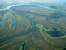
Meanders in the Kobuk River from the air
|
|
| Location | Northwest Arctic Borough, Alaska, USA |
| Nearest city | Kotzebue |
| Coordinates | 67°33′N 159°17′W / 67.550°N 159.283°WCoordinates: 67°33′N 159°17′W / 67.550°N 159.283°W |
| Area | 1,750,716 acres (7,084.90 km2) |
| Established | December 2, 1980 |
| Visitors | 15,500 (in 2016) |
| Governing body | National Park Service |
| Website | Kobuk Valley National Park |
Kobuk Valley National Park is in northwestern Alaska 25 miles (40 km) north of the Arctic Circle. It was designated a United States National Park in 1980 by the Alaska National Interest Lands Conservation Act. It is noted for the Great Kobuk Sand Dunes and caribou migration routes. Park visitors can bring their own gear and go backcountry camping, hiking, backpacking,boating, and dog sledding. There are no designated trails or roads in the park, which at 1,795,280 acres (2,805.12 sq mi; 7,265.24 km2), is approximately the size of the state of Delaware. The park is entirely above the Arctic Circle.
No roads lead to the park. People typically get there by chartered air taxi from Nome, Bettles, or Kotzebue. Flights are available year-round, but heavily weather dependent. The park is one of the least visited in the National Park System.
The park is the center of a vast ecosystem between Selawik National Wildlife Refuge and the Noatak National Preserve. It is over 75 miles (121 km) by river to the Chukchi Sea. The Gates of the Arctic National Park and Preserve lie 32 miles (51 km) to the east. The park includes about 81,000 acres (33,000 ha) of lands owned by native corporations and the State of Alaska.
The park consists of the broad wetlands valley of the Kobuk River which runs along the southern edge of the western Brooks Range, which is known as the Baird Mountains. The boundary of the park runs along the height-of-land of the Baird Mountains in the north and the shorter Waring Mountains in the south that form a ring, defining and enclosing the Kobuk Valley. The middle two-thirds of the Kobuk River, from just above Kiana to just below Ambler, is included in the park, as are several of its major tributaries such as the Salmon River and the Hunt River. The valley floor is mainly covered by glacial drift. Much of the southern portion of the park, south of the Kobuk River, is managed as the Kobuk Valley Wilderness of 174,545 acres (70,636 ha). The Selawik Wilderness lies to the south, in the adjoining Selawik National Wildlife Refuge.
...
Wikipedia

