Nome, Alaska
|
Nome Siqnazuaq |
|
|---|---|
| City | |
| City of Nome | |

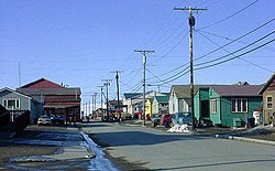
Steadman Street facing North from Front Street. Nome in May 2002
|
|
 Location of Nome, Alaska |
|
| Coordinates: 64°30′14″N 165°23′58″W / 64.50389°N 165.39944°WCoordinates: 64°30′14″N 165°23′58″W / 64.50389°N 165.39944°W | |
| Country | United States |
| State | Alaska |
| Census Area | Nome |
| Incorporated | April 12, 1901 |
| Government | |
| • Type | Council-Manager |
| • Mayor | Richard Beneville |
| • State senator | Donald Olson (D) |
| • State rep. | Neal Foster (D) |
| Area | |
| • Total | 21.6 sq mi (55.9 km2) |
| • Land | 12.5 sq mi (32.5 km2) |
| • Water | 9.1 sq mi (23.5 km2) |
| Elevation | 20 ft (6 m) |
| Population (2010) | |
| • Total | 3,598 |
| • Estimate (2014) | 3,788 |
| • Density | 170/sq mi (64/km2) |
| • Demonym | Nomeite |
| • Census Area | 9,492 |
| Time zone | Alaska (AKST) (UTC-9) |
| • Summer (DST) | AKDT (UTC-8) |
| ZIP Code | 99762 |
| Area code | 907 |
| FIPS code | 02-54920 |
| GNIS feature ID | 1407125, 2419435 |
| Website | www |
Nome (/ˈnoʊm/, Siqnazuaq in Iñupiaq) is a city in the Nome Census Area in the Unorganized Borough of the U.S. state of Alaska. The city is located on the southern Seward Peninsula coast on Norton Sound of the Bering Sea. According to the 2010 Census, the city population was 3,598. The 2014 population estimate was 3,788, suggesting a slight increase. Nome was incorporated on April 9, 1901, and was once the most populous city in Alaska. Nome lies within the region of the Bering Straits Native Corporation.
The city of Nome claims to be home to the world's largest gold pan, although this claim has been disputed by the Canadian city of Quesnel, British Columbia.
In the winter of 1925, a diphtheria epidemic raged among Alaska Natives in the Nome area. Fierce territory-wide blizzard conditions prevented delivery of a life-saving serum by airplane from Anchorage. A relay of dog sled teams was organized to deliver the serum.
...
Wikipedia
