Kluane National Park
| Kluane National Park and Reserve | |
|---|---|
|
IUCN category II (national park)
|
|

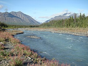
Quill Creek
|
|
| Location of Kluane National Park in Canada | |
| Location | Yukon, Canada |
| Nearest city | Haines Junction |
| Coordinates | 60°37′10″N 138°19′52″W / 60.61943°N 138.331°WCoordinates: 60°37′10″N 138°19′52″W / 60.61943°N 138.331°W |
| Area | 22,013 km2 (8,499 sq mi) |
| Established | 1972 |
| Governing body | Parks Canada |
Kluane National Park and Reserve are two units of Canada's national park system, located in the extreme southwestern corner of the territory of Yukon. Kluane National Park Reserve was established in 1972, covering 22,013 square kilometers (8,499 square miles).
The park includes the highest mountain in Canada, Mount Logan (5,959 meters or 19,551 feet) of the Saint Elias Mountains. Mountains and glaciers dominate the park's landscape, covering 83% of its area. The rest of the land in the park is forest and tundra—east of the largest mountains and glaciers—where the climate is colder and drier than in the western and southern parts of the park. Trees grow only at the park's lowest elevations. The primary tree species are white spruce, balsam poplar and trembling aspen. The park contains about 120 species of birds, including the rock ptarmigan and the golden and bald eagles.
A day-use area with boat launch, picnic facilities and campground is located at Kathleen Lake, and is operated from mid-May to mid-September.Hiking is a popular activity on trails such as St. Elias Lake, Mush Lake Road, Shorty Creek, Cottonwood, Rock Glacier, King's Throne, Kokanee, Auriol, Dezadeash River Trail, Alsek Trail, Sheep Creek Trail, Bullion Plateau Trail, Slims West or Soldiers Summit. Rafting on the Alsek River (a Canadian Heritage river), mountain biking on old mining roads, horseback riding through the Alsek Pass, boating on Kathleen Lake and Mush Lake as well as fishing for lake trout, Arctic grayling, rainbow trout, northern pike and sockeye salmon are also among activities available in the park.
...
Wikipedia

