Klepikovsky District
| Klepikovsky District Клепиковский район (Russian) |
|
|---|---|
 Location of Klepikovsky District in Ryazan Oblast |
|
| Coordinates: 55°08′N 40°10′E / 55.133°N 40.167°ECoordinates: 55°08′N 40°10′E / 55.133°N 40.167°E | |
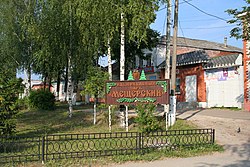
 Entrance to Meshchyora National Park in Klepikovsky District |
|
|
|
|
| Location | |
| Country | Russia |
| Federal subject | Ryazan Oblast |
| Administrative structure (as of 2012) | |
| Administrative center | town of Spas-Klepiki |
| Administrative divisions: | |
| Towns of district significance | 1 |
| Work settlements | 1 |
| Rural okrugs | 23 |
| Inhabited localities: | |
| Cities/towns | 1 |
| Urban-type settlements | 1 |
| Rural localities | 273 |
| Municipal structure (as of December 2008) | |
| Municipally incorporated as | Klepikovsky Municipal District |
| Municipal divisions: | |
| Urban settlements | 2 |
| Rural settlements | 13 |
| Statistics | |
| Area | 3,235 km2 (1,249 sq mi) |
| Population (2010 Census) | 25,476 inhabitants |
| • Urban | 47.4% |
| • Rural | 52.6% |
| Density | 7.88/km2 (20.4/sq mi) |
| Time zone | MSK (UTC+03:00) |
| Official website | |
| on | |
Klepikovsky District (Russian: Клепико́вский райо́н) is an administrative and municipal district (raion), one of the twenty-five in Ryazan Oblast, Russia. It is located in the north of the oblast. The area of the district is 3,235 square kilometers (1,249 sq mi). Its administrative center is the town of Spas-Klepiki. Population: 25,476 (2010 Census);29,391 (2002 Census);34,766 (1989 Census). The population of Spas-Klepiki accounts for 23.2% of the district's total population.
The Mesherskoye peat narrow gauge railway serves a peat factory which became operational in 2013.
...
Wikipedia

