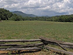
Kituwa
|
Governors Island
|
|

The Kituwa mound at Ferguson Field
|
|
| Location | U.S. Route 19 east of Bryson City, near Bryson City, North Carolina |
|---|---|
| Coordinates | 35°26′00″N 83°26′00″W / 35.43333°N 83.43333°WCoordinates: 35°26′00″N 83°26′00″W / 35.43333°N 83.43333°W |
| Area | 20 acres (8.1 ha) |
| NRHP Reference # | 73002239 |
| Added to NRHP | June 4, 1973 |
The Cherokee believe the ancient settlement of Kituwa (also spelled Kituwah, Keetoowah, Kittowa, Kitara and other similar variations) or giduwa (Cherokee:ᎩᏚᏩ), on the Tuckasegee River is their original settlement and is one of the "seven mother towns" in the Southeast. It is in Swain County, North Carolina, in the Great Smoky Mountains, near present-day Bryson City.
Kituwa is the site of an ancient earthwork mound, likely built by the Mississippian culture about 1000 CE. The Cherokee held the site sacred after settling here in a later time. Although the vegetation on the mound was burned repeatedly by the Cherokee for agriculture during the colonial period and plowed over for corn cultivation since Indian Removal in the 1830s, the mound is still visible.
During the period of European-American agricultural uses, the larger property was called Ferguson's Field. The mound is 170 feet (52 m) in diameter and five feet tall, although it was once taller. The Cherokee built a structure on top that housed their sacred flame, which was to be kept burning at all times.
Moundbuilding by people of the various Woodland and Mississippian cultures was common throughout the Mississippi Basin and Ohio Valley. This included Tennessee to the west, Georgia to the southeast, Louisiana to the southwest, and Ohio, Indiana, Illinois, and Missouri to the northwest.
...
Wikipedia


