Kis-Küküllő County
| Kis-Küküllő County Comitatus Cuculiensis Minor (Latin) Kis-Küküllő vármegye (Hungarian) Komitat Klein-Kokelburg (German) Comitatul Târnava-Mică (Romanian) |
|||||
| County of the Kingdom of Hungary | |||||
|
|||||
|
Coat of arms |
|||||
| Capital |
Dicsőszentmárton 46°20′N 24°18′E / 46.333°N 24.300°ECoordinates: 46°20′N 24°18′E / 46.333°N 24.300°E |
||||
| History | |||||
| • | Established | 1876 | |||
| • | Treaty of Trianon | 4 June 1920 | |||
| Area | |||||
| • | 1910 | 1,724 km2(666 sq mi) | |||
| Population | |||||
| • | 1910 | 116,091 | |||
| Density | 67.3 /km2 (174.4 /sq mi) | ||||
| Today part of | Romania | ||||
| Târnăveni is the current name of the capital. | |||||
Coat of arms
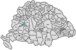
Kis-Küküllő was an administrative county (comitatus) of the Kingdom of Hungary. Its territory is now in central Romania (central Transylvania). Kis-Küküllő is the Hungarian name for the Târnava Mică River. The capital of the county was Dicsőszentmárton (now Târnăveni).
Kis-Küküllő county shared borders with the Hungarian counties Alsó-Fehér, Torda-Aranyos, Maros-Torda, Udvarhely and Nagy-Küküllő. The Maros river formed part of its northern border, the Nagy-Küküllő river its southern border. The Kis-Küküllő flowed through the county. Its area was 1724 km² around 1910.
Kis-Küküllő county was formed when the county Küküllő was split in 1876, when the administrative structure of Transylvania was changed. In 1920 by the Treaty of Trianon the county became part of Romania. Its territory lies in the present Romanian counties Mureş (a.o. Târnăveni), Alba (the south-west) and Sibiu (the south, a.o. Dumbrăveni).
...
Wikipedia


