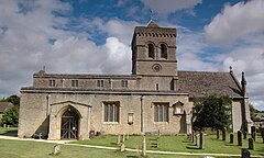
Kirtlington
| Kirtlington | |
|---|---|
 St Mary the Virgin parish church |
|
| Kirtlington shown within Oxfordshire | |
| Area | 14.51 km2 (5.60 sq mi) |
| Population | 988 (2011 Census) (parish, including Northbrook) |
| • Density | 68/km2 (180/sq mi) |
| OS grid reference | SP5019 |
| Civil parish |
|
| District | |
| Shire county | |
| Region | |
| Country | England |
| Sovereign state | United Kingdom |
| Post town | Kidlington |
| Postcode district | OX5 |
| Dialling code | 01869 |
| Police | Thames Valley |
| Fire | Oxfordshire |
| Ambulance | South Central |
| EU Parliament | South East England |
| UK Parliament | |
| Website | Kirtlington Oxfordshire |
Kirtlington is a village and civil parish in Oxfordshire about 6 1⁄2 miles (10.5 km) west of Bicester. The parish includes the hamlet of Northbrook. The 2011 Census recorded the parish's population as 988.
The Portway is a pre-Roman road running parallel with the River Cherwell on high ground about 1 mile (1.6 km) east of the river. It bisects Kirtlington parish and passes through the village. A short stretch of it is now part of the A4095 road through the village. Longer stretches form minor roads to Bletchington and Upper Heyford.
Akeman Street Roman road bisects the parish east–west passing just north of Kirtlington village. A 4-mile (6.4 km) minor road linking Kirtlington with Chesterton uses its course. Aves ditch is pre-Saxon. One end of the ditch is in Kirtlington parish about 1 mile (1.6 km) north of the village.
The earliest known historical record of Kirtlington is from AD 945. In 977 King Edward the Martyr held a witenagemot at Kirtlington attended by Dunstan, Archbishop of Canterbury. In the 11th century Kirtlington was a royal manor of Edward the Confessor. The Domesday Book records that in 1086 Cherielintone was now a royal manor of the conquering Norman monarchy. It remained a royal manor until 1604 when the Crown sold it to two wealthy Londoners.
...
Wikipedia

