Kings Langley, New South Wales
|
Kings Langley Sydney, New South Wales |
|||||||||||||
|---|---|---|---|---|---|---|---|---|---|---|---|---|---|

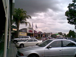
Kings Langley Shopping Centre
|
|||||||||||||
| Coordinates | 33°45′S 150°55′E / 33.75°S 150.92°ECoordinates: 33°45′S 150°55′E / 33.75°S 150.92°E | ||||||||||||
| Population | 9,267 (2011 census) | ||||||||||||
| Established | 1976 | ||||||||||||
| Postcode(s) | 2147 | ||||||||||||
| Location | 39 km (24 mi) tt of Sydney CBD | ||||||||||||
| LGA(s) | Blacktown | ||||||||||||
| State electorate(s) | |||||||||||||
| Federal Division(s) | Greenway | ||||||||||||
|
|||||||||||||
Kings Langley is a suburb of Sydney, in the state of New South Wales, Australia. Kings Langley is located 28.3 kilometres north-west in a straight line from the Sydney central business district in the local government area of the City of Blacktown. Kings Langley is part of the Hills District and Greater Western Sydney region. Kings Langley has no overhead powerlines. The real estate website Homely ranked it the 14th best suburb in Sydney (Greater).
Early settler Matthew Pearce (1762-1831) called his 160 acres (65 ha) grant after Kings Langley Manor House in Hertfordshire, England, where he was said to have been born. Pearce’s grant was situated on the opposite side of the Old Windsor Road to the present day suburb of Kings Langley. A housing scheme used the name in the 1970s and it was recognised as a "neighbourhood" in 1976 and assigned as a suburb in 1987.
Kings Langley is well serviced by public transport, including Hillsbus routes T61 and 706. The Busways routes 743 and 718 also service the suburb and connect it with the larger suburbs of Blacktown, Castle Hill, Seven Hills and Parramatta.
The suburb is serviced by Joseph Banks and Trobadour stations on the North-west T-way, providing connections to North Sydney (602), Sydney CBD (607X, 617X), Macquarie Park (740), Rouse Hill (T63, T64, T65, T66) and Parramatta (T60-T66) as well as James Cook station on the Blacktown- Parklea T-way, providing services to Blacktown (T70-T75), Castle Hill (T70, T71), Rouse Hill (T71, T75) and Schofields (T74).
...
Wikipedia

