Kings Langley
| Kings Langley | |
|---|---|
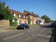
 Kings Langley High Street, looking north. |
|
| Kings Langley shown within Hertfordshire | |
| Population | 5,072 (Census 2001) 5,214 (Census 2011) |
| OS grid reference | TL067030 |
| District | |
| Shire county | |
| Region | |
| Country | England |
| Sovereign state | United Kingdom |
| Post town | KINGS LANGLEY |
| Postcode district | WD4 |
| Dialling code | 01923 |
| Police | Hertfordshire |
| Fire | Hertfordshire |
| Ambulance | East of England |
| EU Parliament | East of England |
| UK Parliament | |
Kings Langley is a historic village and civil parish in Hertfordshire, England, 21 miles (34 km) northwest of central London to the south of the Chiltern Hills and now part of the London commuter belt. The village is divided between two local government districts by the River Gade with the larger western portion in the Borough of Dacorum and smaller part, to the east of the river, in Three Rivers District.
It was once the location of Kings Langley Palace, a royal palace of the Plantagenet kings of England. The 12th century parish church of All Saints' houses the tomb of Edmund of Langley (1341–1402), the first Duke of York.
It is 2 miles (3.2 km) south of Hemel Hempstead and 2 miles (3.2 km) north of Watford.
The place-name Langley is first attested here in a Saxon charter of circa 1050, where it appears as Langalega. It is spelt Langelai in the Domesday Book of 1086, and is recorded as Langel' Regis in 1254. The name means 'long wood or clearing'.
A Roman villa has been excavated just south of the village.
The town was probably part of the lands of the Abbey of St. Albans, although actual records have been lost. At the Norman conquest the manor was given to William's half brother Robert, Count of Mortain who let it to one Ralf. It is around the manor that the present village developed as a linear village lying on the old road from London to Berkhamsted and the Midlands of England. In the Domesday Book of 1086, Langley was in the hundred of Danish.
...
Wikipedia

