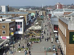
Hemel Hempstead
| Hemel Hempstead | |
|---|---|
 Marlowes shopping area in Hemel Hempstead |
|
| Hemel Hempstead shown within Hertfordshire | |
| Population | 94,932 (2011 Census) |
| OS grid reference | TL 056 071 |
| District | |
| Shire county | |
| Region | |
| Country | England |
| Sovereign state | United Kingdom |
| Post town | HEMEL HEMPSTEAD |
| Postcode district | HP1, HP2, HP3 |
| Dialling code | 01442 |
| Police | Hertfordshire |
| Fire | Hertfordshire |
| Ambulance | East of England |
| EU Parliament | East of England |
| UK Parliament | |
Hemel Hempstead /ˈhɛməl ˈhɛmpstᵻd/ is a large new town in Hertfordshire in the East of England, 24 miles (39 km) northwest of London and part of the Greater London Urban Area. The population according to the 2001 Census was 81,143, and at the 2011 census was 94,932. Developed after the Second World War as a new town, it has existed as a settlement since the 8th century and was granted its town charter by King Henry VIII in 1539. It is part of the district (and borough since 1984) of Dacorum and the Hemel Hempstead constituency.
The settlement was called by the name Henamsted or Hean-Hempsted in Anglo-Saxon times and in William the Conqueror's time by the name of Hemel-Amstede. The name is referred to in the Domesday Book as "Hamelamestede", but in later centuries it became Hamelhamsted, and, possibly, Hemlamstede. In Old English, "-stead" or "-stede" simply meant a place, such as the site of a building or pasture, as in clearing in the woods, and this suffix is used in the names of other English places such as and Berkhamsted.
...
Wikipedia

