Killanaboy
| Kilnaboy | |
|---|---|
| Village, townland, civil parish | |

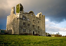
Leamaneh Castle
|
|
| Location in Ireland | |
| Coordinates: 52°58′11″N 9°05′07″W / 52.9697°N 9.0854°WCoordinates: 52°58′11″N 9°05′07″W / 52.9697°N 9.0854°W | |
| Country | Ireland |
| Province | Munster |
| County | County Clare |
| Population (2011) | |
| • Total | 689 |
| Time zone | WET (UTC+0) |
| • Summer (DST) | IST (WEST) (UTC-1) |
Kilnaboy or Killinaboy (Irish: Cill Iníne Baoith, meaning "church of Baoth's daughter") is a village, townland and civil parish in County Clare, Ireland. It is located in the Burren, and as of the 2011 census the area had 347 inhabitants.
Kilnaboy is a parish in the historic Barony of Inchiquin. Its chief town, Corofin, is located on the southern extremity of the parish. It is mentioned with regard to the Papal taxation of 1302-06.
It is located on the southeastern border of the limestone hills of the Burren and extends both into the lowlands to the south and into the hills to the north. Mullaghmore mountain is close by. There are extensive tracts of bog in the eastern portion of the parish. According to the 1837 survey of Lewis:
"The surface is boldly diversified and embellished with the picturesque lakes of Inchiquin and Tadune, the latter of which is but partly in the parish. The lake of Inchiquin is about 2½ miles in circumference, and is situated at the base of a richly wooded range of hills, forming a fine contrast to the bare limestone rocks in the vicinity."
Most of Inchiquin Lough is located in the parish, except for a small area in the southwest which lies in the parish of Rath, County Clare.
There are over 300 national monuments in the area including Leamaneh Castle and Cahercommaun stone fort. On Roughan Hill there are a number of prehistoric structures including several wedge tombs such as Parknabinnia wedge tomb. Other wedge tombs are located in Tullycommon and Slievenaglasha townlands.
...
Wikipedia

