Kikaijima
|
Native name: 喜界島, Kikai-ga-jima Nickname: Kyaa |
|
|---|---|

Hyakunodai, Kikaijima
|
|
| Geography | |
| Location | East China Sea |
| Coordinates | 28°19′35″N 129°58′27″E / 28.32639°N 129.97417°ECoordinates: 28°19′35″N 129°58′27″E / 28.32639°N 129.97417°E |
| Archipelago | Amami Islands |
| Area | 56.93 km2 (21.98 sq mi) |
| Coastline | 48.6 km (30.2 mi) |
| Highest elevation | 214 m (702 ft) |
| Administration | |
|
Japan
|
|
| Prefectures | Kagoshima Prefecture |
| District | Ōshima District |
| Town | Kikai |
| Demographics | |
| Population | 7,657 (2013) |
| Ethnic groups | Japanese |
Not to be confused with Kikai Caldera, which is submerged in the Ōsumi Islands
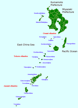
Kikaijima (喜界島?, also Kikai-ga-jima; Amami: キャー Kyaa) is one of the Satsunan Islands, classed with the Amami archipelago between Kyūshū and Okinawa.
The island, 56.93 square kilometres (21.98 sq mi) in area, has a population of approximately 7,657 persons. Administratively the island forms the town of Kikai, Kagoshima Prefecture. Much of the island is within the borders of the Amami Guntō Quasi-National Park.
Kikaijima is isolated from the other Amami islands, and is located approximately 25 kilometres (13 nmi; 16 mi) east of Amami Ōshima and approximately 380 kilometres (210 nmi; 240 mi) south of the southern tip of Kyūshū. It is the easternmost island in the Amami chain. Compared with Amami Ōshima and Tokunoshima, Kikaijima is a relatively flat island, with its highest point at 214 metres (702 ft) above sea level. It is a raised coral island with limestone cliffs, and draws the attention of geologists as it is one of the fastest rising coral islands in the world.
The climate of Kikaijima is classified as has a humid subtropical climate (Köppen climate classification Cfa) with very warm summers and mild winters. The rainy season lasts from May through September. The island is subject to frequent typhoons.
...
Wikipedia

