Kiel Canal
| Nord-Ostsee-Kanal | |
|---|---|

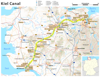
Current map of Kiel Canal in Schleswig-Holstein
|
|
| Specifications | |
| Length | 61 miles (98 km) |
| History | |
| Construction began | 1887 |
| Date completed | 1895 |
| Date extended | 1907–14 |
| Geography | |
| Start point | Brunsbüttel (North Sea) |
| End point | Kiel (Baltic Sea) |
The Kiel Canal (German: Nord-Ostsee-Kanal, literally "North-[to]-Baltic Sea canal", formerly known as the Kaiser-Wilhelm-Kanal) is a 98-kilometre (61 mi) long freshwater canal in the German state of Schleswig-Holstein. The canal was finished in 1895, but later widened, and links the North Sea at Brunsbüttel to the Baltic Sea at Kiel-Holtenau. An average of 250 nautical miles (460 km) is saved by using the Kiel Canal instead of going around the Jutland Peninsula. This not only saves time but also avoids storm-prone seas and having to pass through the Øresund straits.
Besides its two sea entrances, the Kiel Canal is linked, at Oldenbüttel, to the navigable River Eider by the short Gieselau Canal.
The first connection between the North and Baltic Seas was constructed while the area was ruled by Denmark-Norway. It was called the Eider Canal, which used stretches of the Eider River for the link between the two seas. Completed during the reign of Christian VII of Denmark in 1784, the Eiderkanal was a 43-kilometre (27 mi) part of a 175-kilometre (109 mi) waterway from Kiel to the Eider River's mouth at Tönning on the west coast. It was only 29 metres (95 ft) wide with a depth of 3 metres (10 ft), which limited the vessels that could use the canal to 300 tonnes.
After 1864 Second Schleswig War put Schleswig-Holstein under the government of Prussia (from 1871 the German Empire), a new canal was sought by merchants and by the German navy, which wanted to link its bases in the Baltic and the North Sea without the need to sail around Denmark.
...
Wikipedia
