Kiel Airport
|
Kiel Airport Flughafen Kiel |
|||||||||||
|---|---|---|---|---|---|---|---|---|---|---|---|
 |
|||||||||||
 |
|||||||||||
| Summary | |||||||||||
| Airport type | Public | ||||||||||
| Owner |
State of Schleswig-Holstein (55%) City of Kiel (45%) |
||||||||||
| Serves | Kiel, Germany | ||||||||||
| Elevation AMSL | 101 ft / 31 m | ||||||||||
| Coordinates | 54°22′46″N 010°08′43″E / 54.37944°N 10.14528°ECoordinates: 54°22′46″N 010°08′43″E / 54.37944°N 10.14528°E | ||||||||||
| Website | airport-kiel.de | ||||||||||
| Map | |||||||||||
| Location of Kiel Airport | |||||||||||
| Runways | |||||||||||
|
|||||||||||
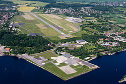
Kiel Airport (German: Flughafen Kiel, IATA: KEL, ICAO: EDHK) is a small regional airport in Kiel, Germany. It is located in the borough of Holtenau, 8.3 km (5.2 mi) north of the city centre. It is registered as a public airfield (German: Verkehrslandeplatz). As of 2006, it served 30,528 passengers p. a.
The aerodrome was built in 1914 on a plain area that had been created from material dug out during the construction of the Kiel Canal. In 1927, the Kiel Airport Company (German: Kieler Flughafengesellschaft) was founded, which operated the State Airport of Kiel (German: Landflughafen Kiel). During this time, there were 27 national and international destinations. In 1937, the airport was designated a military airbase. However, it continued to be used for civilian flights, such as scheduled flights to Braunschweig and Berlin (Tempelhof).
Its taxiways were extended in 1963, a first terminal was built in 1965. This terminal was used for scheduled flights to West Berlin operated by Pan Am.
In 1987, the terminal that is still used today was built. At the same time Lufthansa began offering scheduled flights to Frankfurt, and later to Cologne/Bonn, Munich, Copenhagen, Kaliningrad and Riga.
...
Wikipedia

