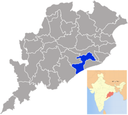
Khurda (District)
|
Khordha ଖୋର୍ଦ୍ଧା ଜିଲ୍ଲା Khurda |
|
|---|---|
| District | |
| Nickname(s): Paika District of Odisha ପାଇକ ଜିଲ୍ଲା |
|
 Location in Odisha, India |
|
| Coordinates: 20°09′58″N 85°39′58″E / 20.166°N 85.666°ECoordinates: 20°09′58″N 85°39′58″E / 20.166°N 85.666°E | |
| Country |
|
| State | Odisha |
| Headquarters | Khordha |
| Government | |
| • Collector | Niranjan Sahoo (OAS) |
| Area | |
| • Total | 2,887.5 km2 (1,114.9 sq mi) |
| Population (2011) | |
| • Total | 2,251,673 |
| • Density | 800/km2 (2,000/sq mi) |
| Languages | |
| • Official | Odia, English |
| Time zone | IST (UTC+5:30) |
| PIN | 751 xxx, 752 xxx |
| Telephone code | 674, 6755, 6756 |
| Vehicle registration | OD-02/OD-33 |
| Nearest city | Bhubaneswar |
| Sex ratio | 1.108 ♂/♀ |
| Literacy | 87.51% |
| Lok Sabha constituency | 2 |
| Vidhan Sabha constituency | 6 |
| Climate | Aw (Köppen) |
| Precipitation | 1,443 millimetres (56.8 in) |
| Avg. summer temperature | 41.4 °C (106.5 °F) |
| Avg. winter temperature | 9.5 °C (49.1 °F) |
| Website | www |
| Bhubaneswar | ||||||||||||||||||||||||||||||||||||||||||||||||||||||||||||
|---|---|---|---|---|---|---|---|---|---|---|---|---|---|---|---|---|---|---|---|---|---|---|---|---|---|---|---|---|---|---|---|---|---|---|---|---|---|---|---|---|---|---|---|---|---|---|---|---|---|---|---|---|---|---|---|---|---|---|---|---|
| Climate chart () | ||||||||||||||||||||||||||||||||||||||||||||||||||||||||||||
|
||||||||||||||||||||||||||||||||||||||||||||||||||||||||||||
|
||||||||||||||||||||||||||||||||||||||||||||||||||||||||||||
| J | F | M | A | M | J | J | A | S | O | N | D |
|
12
28
16
|
24
32
19
|
24
35
22
|
22
37
25
|
56
38
27
|
196
35
26
|
325
32
25
|
330
31
25
|
288
32
25
|
208
31
23
|
37
30
19
|
28
28
15
|
| Average max. and min. temperatures in °C | |||||||||||
| Precipitation totals in mm | |||||||||||
| Source: IMD | |||||||||||
| Imperial conversion | |||||||||||
|---|---|---|---|---|---|---|---|---|---|---|---|
| J | F | M | A | M | J | J | A | S | O | N | D |
|
0.5
83
60
|
1
89
65
|
1
95
72
|
0.9
99
77
|
2.2
100
80
|
7.7
96
79
|
13
89
77
|
13
89
77
|
11
89
77
|
8.2
89
73
|
1.5
Wikipedia
...
| |
