Khodad
| Khodad | |
|---|---|
| Town | |

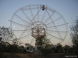
Giant Metrewave Radio Telescope (GMRT) near Narayangaon
|
|
| Location in Maharashtra, India | |
| Coordinates: 19°07′00″N 73°55′00″E / 19.11667°N 73.91667°ECoordinates: 19°07′00″N 73°55′00″E / 19.11667°N 73.91667°E | |
| Country |
|
| State | Maharashtra |
| District | Pune |
| Taluka | Junnar |
| Elevation | 656 m (2,152 ft) |
| Languages | |
| • Official | Marathi |
| Time zone | IST (UTC+5:30) |
| PIN | 410504 |
| Telephone code | 91-2132-XXXXXX |
| Vehicle registration | MH-14 |
Khodad (Marathi: खोडद ), is a town in the Pune district of Maharashtra state, India. Khodad Village is situated in Junner taluka of Pune district of Maharashtra state, India. It is famous for Giant Metrewave Radio Telescope (GMRT), the largest telescope at metre wavelengths in the world, which attracts radio astronomers from different countries. Khodad is located on Junner & Ambegao taluka border. Khodad is surrounded by Junnar Taluka towards west, Khed Taluka towards South, Parner & Ambegaon Taluka towards East, Shirur Taluka towards North.
Village is at 9 Kilometer from Narayangaon, which is one of the most important town in Pune District. Location of Khodad is on East of Narayangao towards Ambegao taluka. Situated at 87 km from pune on Pune Nashik highway. this region belongs to Desh or Paschim Maharashtra region. It fallows under Pune Division. It is at 26 km from Junnar, taluka headquarters. 5 170 km from Mumbai State capital of Maharashtra.4 Jadhavwadi (3 km), Thorandale (5 km), Ranjani (5 km), Walati (6 km), Bhorwadi (2 km), Nagapur (7 km) are the nearby villages to Khodad. Manchar, Junnar, Shirur, Talegaon Dabhade are the nearby Cities to Khodad. Village is situated at bank of Meena River. There is pyramid Shape Mountain at East of Khodad towards Parner taluka end. Local people call it as Khodad che Pathar (plateau of Khodad) Manjarwadi is located at 5 km West from Khodad. On South on the opposite side of Meena River there is hermitage of Mahanubhav panth. Narayangad is located at 5 kilometer North of Khodad. It is believed that Narayangao got its name from this fort. The fort is from the Satvahan dynasty and was used as a watch point for the Junnar Paithan route.
The population of Village is around 4500 to 5000. Marathi is the main language of majority of the people. Hindi & Urdu is also used by minority people. The Village is divided roughly on the bases of people living in that particular vicinity. Main Village,Mule mala, Gakiwad mala, Ghangale Mala, Kharmale Mala, Erande mala near Datta temple in Erande mala 5-6 boys in the army, are some of the main parts (mala in local language) of Village base upon the Surname of people live in that area. Majority of the Population is Hindu. But there is quite considerable numbers of Muslim Families in Khodad engage in their Family business like Kasar, Mutton Shop or Small shop in Village market area.
...
Wikipedia

