Kfar Bir'im
| Kafr Bir'im | |
|---|---|

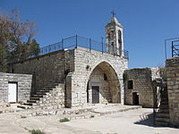
The church of Kafr Bir'im
|
|
| Arabic | كفر برعم |
| Name meaning | The village of Bir'im |
| Also spelled | Kefr Berem |
| Subdistrict | Safad |
| Coordinates | 33°02′37″N 35°24′51″E / 33.04361°N 35.41417°ECoordinates: 33°02′37″N 35°24′51″E / 33.04361°N 35.41417°E |
| Palestine grid | 189/272 |
| Population | 710 (1945) |
| Area | 12,250 dunams 12.3 km² |
| Date of depopulation | early November 1948 |
| Cause(s) of depopulation | Expulsion by Yishuv forces |
| Current localities | Bar'amDovev |
Kafr Bir'im, also Kefr Berem (Arabic: كفر برعم, Hebrew: כְּפַר בִּרְעָם), was a Palestinian Arab village in Mandatory Palestine, located in modern-day northern Israel, 4 kilometers (2.5 mi) south of the Lebanese border and 11.5 kilometers (7.1 mi) northwest of Safed. The village was situated 750 meters (2,460 ft) above sea level, with a church overlooking it at an elevation of 752 meters (2,467 ft). The church was built on the ruins of an older church destroyed in the earthquake of 1837. In 1945, 710 people lived in Kafr Bir'im, most of them Christians. By 1992, the only standing structure was the church and belltower.
Kafr Bir'im is built on the site of the ancient Jewish village of Kfar Bar'am, from which the name is derived. The remains of the a 3rd-century Synagogue of Kfar Bar'am are still visible. Rabbi Phinehas ben Jair (2nd-century CE) is said to have been buried in Kfar Bar'am.
A visitor in the thirteenth century described an Arab village containing the remains of two ancient synagogues.
In 1596, Kafr Bir'im appeared in Ottoman tax registers as being in the Nahiya of Jira of the Liwa of Safad. It had a population of 114 Muslim households and 22 bachelors.
...
Wikipedia

