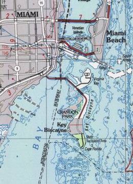
Key Biscayne
| Map of Key Biscayne | |
| Geography | |
|---|---|
| Location | Miami-Dade County, Florida |
| Coordinates | 25°41′25″N 80°09′54″W / 25.690329°N 80.165118°WCoordinates: 25°41′25″N 80°09′54″W / 25.690329°N 80.165118°W |
| Length | 5 mi (8 km) |
| Width | 1.5 mi (2.4 km) |
| Highest elevation | 5 ft (1.5 m) |
| Administration | |
|
United States
|
|
Key Biscayne (Spanish: Cayo Vizcaíno) is an island located in Miami-Dade County, Florida, United States, between the Atlantic Ocean and Biscayne Bay. It is the southernmost of the barrier islands along the Atlantic coast of Florida, and lies south of Miami Beach and southeast of Miami. The key is connected to Miami via the Rickenbacker Causeway, originally built in 1947.
The northern portion of Key Biscayne is home to Crandon Park, a county park. The middle section of the island consists of the incorporated Village of Key Biscayne. The southern part of the island is now protected as Bill Baggs Cape Florida State Park, adjacent to Biscayne National Park, one of the two national parks in Miami-Dade County.
Key Biscayne, although named a "key", is not geologically part of the Florida Keys, but is a barrier island composed of sand eroded from the Appalachian Mountains, carried to the coast by rivers and then moved along the coast from the north by coastal currents. There is no hard bedrock near the surface of the island, only layers of weak "shelly sandstone" to depths of 100 feet (30 m) or more. The coastal transport of sand southward ends at Key Biscayne. In the 1850s Louis Agassiz noted that "[s]outh of Cape Florida no more silicacious sand is to be seen." (The beaches in the Florida Keys, by contrast, consist primarily of finely pulverized shells.)Geologists believe that the island emerged around 2000 BCE, soon after the sea level stopped rising, as the sand built up to form new barrier islands on the southern Florida coast.
...
Wikipedia

