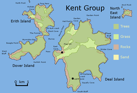
Kent Group

A map of the Kent Group
|
|
|
Location of the Kent Group in Bass Strait
|
|
| Etymology | William Kent |
|---|---|
| Geography | |
| Location | Bass Strait |
| Coordinates | 39°27′36″S 147°19′48″E / 39.46000°S 147.33000°ECoordinates: 39°27′36″S 147°19′48″E / 39.46000°S 147.33000°E |
| Total islands | 6 |
| Major islands | Deal Island |
| Area | 1,576 ha (3,890 acres) |
| Administration | |
| State | Tasmania |
|
Kent Group National Park Tasmania |
|
|---|---|
|
IUCN category II (national park)
|
|
| Nearest town or city | Launceston |
| Established | 1947 |
| Area | 165 km2 (63.7 sq mi) |
| Visitation | 25,000 (in 1998) |
| Managing authorities | Tasmania Parks and Wildlife Service |
| Website | Kent Group National Park |
| See also | Protected areas of Tasmania |
The Kent Group are a grouping of six granite islands located in Bass Strait, north-west of the Furneaux Group in Tasmania, Australia. Collectively, the group is comprised within the Kent Group National Park.
The islands were named Kent's Group by Matthew Flinders, "in honour of my friend captain William Kent, then commander of Supply" when Flinders passed them on 8 February 1798 in Francis (on her way to salvage Sydney Cove). The largest island in the group is Deal Island; the others, in order of descending size, are Erith Island, Dover Island, North East Isle, South West Isle and Judgement Rocks.
Murray Pass, named for the explorer John Murray, between Deal and Erith Islands has long been used by ships to shelter from gales in Bass Strait, but it is a dangerous, partly open, roadstead, and many ships have been wrecked after sudden changes in wind direction and speed. Others have hit the island either while attempting to shelter or through poor navigation in darkness or bad weather, several with heavy loss of life. They include:
...
Wikipedia

