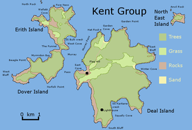
Deal Island (Tasmania)

The Deal Island is the largest of the Kent Group.
|
|
|
Location of the Deal Island in Bass Strait
|
|
| Geography | |
|---|---|
| Location | Bass Strait |
| Coordinates | 39°28′12″S 147°19′12″E / 39.47000°S 147.32000°ECoordinates: 39°28′12″S 147°19′12″E / 39.47000°S 147.32000°E |
| Archipelago | Kent Group |
| Area | 1,576 ha (3,890 acres) |
| Administration | |
| State | Tasmania |
The Deal Island, the largest island of the Kent Group, is a 1,576-hectare (3,890-acre) granite island, located in northern Bass Strait, that lies between the Furneaux Group, north-east of Tasmania and Wilsons Promontory in Victoria, Australia.
The island is contained entirely within the 2,374-hectare (5,870-acre) Kent Group National Park, Tasmania’s northernmost national park, gazetted in 2002. In 2004 the national park was extended to include the state waters of the three major islands of the Kent Group marine waters, encapsulating 29,000 hectares (72,000 acres) of marine reserve.
The Deal Island is located at the southern end of the 292,800-hectare (724,000-acre) Beagle Commonwealth Marine Reserve, that encloses the Kent Group Marine Reserve and the Hogan and Curtis Island groups.
Deal Island has been extensively modified in the past by human activity in the construction of facilities and the vegetation clearance and regular firing associated with grazing livestock. It has a lighthouse, airstrip (closed), roads, jetty, two houses, a dam and a museum.
Deal Island has the highest lighthouse in the Southern Hemisphere, standing 305 metres (1,001 ft) above sea level and was sometimes visible at night from Wilson's Promontory, 80 kilometres (50 mi) away. The lighthouse was built in 1848 and deactivated in 1992. While active, the height caused problems with visibility in low cloud conditions. Management and conservation is under the control of the Tasmania Parks and Wildlife Service.
...
Wikipedia

