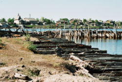
Kem, Russia
| Kem (English) Кемь (Russian) Kemi (Karelian) |
|
|---|---|
| - Town - | |
 Kem and its harbor |
|
 Location of the Republic of Karelia in Russia |
|
|
|
|
|
|
|
|
|
|
| Administrative status (as of April 2013) | |
| Country | Russia |
| Federal subject | Republic of Karelia |
| Administrative district | Kemsky District |
| Administrative center of | Kemsky District |
| Municipal status (as of April 2013) | |
| Municipal district | Kemsky Municipal District |
| Urban settlement | Kemskoye Urban Settlement |
| Administrative center of | Kemsky Municipal District, Kemskoye Urban Settlement |
| Statistics | |
| Population (2010 Census) | 13,051 inhabitants |
| Time zone | MSK (UTC+03:00) |
| First mentioned | 1450 |
| Town status since | 1785 |
| Postal code(s) | 18661x |
| Dialing code(s) | +7 81458 |
| on | |
Kem (Russian: Кемь; Finnish and Karelian: Kemi) is a historic town and the administrative center of Kemsky District of the Republic of Karelia, Russia, located on the shores of the White Sea where the Kem River enters it, on the railroad leading from Petrozavodsk to Murmansk. Population: 13,051 (2010 Census);14,620 (2002 Census);18,522 (1989 Census).
![]() Novgorod Republic 1450–1478
Novgorod Republic 1450–1478![]() Grand Duchy of Moscow 1478–1547
Grand Duchy of Moscow 1478–1547![]() Tsardom of Russia 1547–1721
Tsardom of Russia 1547–1721![]() Russian Empire 1721–1917
Russian Empire 1721–1917![]() Russian Republic 1917
Russian Republic 1917![]() Soviet Russia 1918–1922
Soviet Russia 1918–1922![]() Soviet Union 1922–1991
Soviet Union 1922–1991![]() Russian Federation 1991–present
Russian Federation 1991–present
...
Wikipedia


