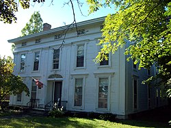
Keeney House (Le Roy, New York)
|
Keeney House
|
|

North elevation and west profile, 2010
|
|
| Location | Le Roy, NY |
|---|---|
| Nearest city | Batavia |
| Coordinates | 42°58′38″N 77°59′35″W / 42.97722°N 77.99306°WCoordinates: 42°58′38″N 77°59′35″W / 42.97722°N 77.99306°W |
| Area | 0.75 acres (3,000 m2) |
| Built | 1851 |
| Architect | Philo L. Pierson; Bryant Fleming |
| Architectural style | Federal Revival |
| NRHP reference # | 79001583 |
| Added to NRHP | September 11, 1979 |
The Keeney House is located on Main Street (New York State Route 5) in Le Roy, New York, United States. It is a two-story wood frame house dating to the mid-19th century. Inside it has elaborately detailed interiors. It is surrounded by a landscaped front and back yard.
Originally it was in the Greek Revival architectural style, with more elaborate decoration on its main facade. During the late 19th and early 20th centuries, it was home to horticulturist Calvin N. Kenney (1849–1930), breeder of the stringless bean. In 1927, the home was renovated in the Federal Revival style by Bryant Fleming, leaving it with a more restrained main facade. The house and its carriage house were listed on the National Register of Historic Places in 1979.
The house is located on a three-quarter–acre (3,000 m²) lot, more than twice as deep as it is wide, on the south side of Main Street, just east of its intersection with Lake and Clay streets (New York State Route 19) in the center of the village. Most of the neighboring properties are large non-residential structures: a supermarket to the west, the village hall to the east with Le Roy's commercial district on the other side of Route 19, and another large commercial structure to the north across the street. A block of residences begins to the northwest. The terrain begins to slope slightly downward to the east and Oatka Creek at that point.
Mature trees and shrubs are planted throughout the landscaped lot. The house sits on a slight rise, with slight terraces climbing up to it from the street. A line of trees screens the property from the village hall property on the east, next to a driveway to the carriage house, and a decorative wooden fence runs from the carriage house along the rear boundary.
...
Wikipedia


