Kasos
|
Kasos Κάσος |
|
|---|---|

Old Harbor of Fry
|
|
| Coordinates: 35°24′N 26°55′E / 35.400°N 26.917°ECoordinates: 35°24′N 26°55′E / 35.400°N 26.917°E | |
| Country | Greece |
| Administrative region | South Aegean |
| Regional unit | Karpathos |
| Area | |
| • Municipality | 69.464 km2 (26.820 sq mi) |
| Highest elevation | 550 m (1,800 ft) |
| Lowest elevation | 0 m (0 ft) |
| Population (2011) | |
| • Municipality | 1,084 |
| • Municipality density | 16/km2 (40/sq mi) |
| Time zone | EET (UTC+2) |
| • Summer (DST) | EEST (UTC+3) |
| Postal code | 85800 |
| Area code(s) | 22450 |
| Vehicle registration | ΚΧ, ΡΟ, ΡΚ |
| Website | www.kasos.gr |
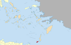
Kasos (/ˈkɑːsoʊs/; also Kassos; Greek: Κάσος) is a Greek island municipality in the Dodecanese. It is the southernmost island in the Aegean Sea, and is part of the Karpathos regional unit. As of 2011[update], its population was 1,084. The island has also been known in Italian as Caso, and Turkish as Kaşot.
Kasos lies SW of Karpathos, between this island and Crete. Adjacent to the island is the Strait of Kasos, through which some of the Modified Atlantic Water enters the Sea of Crete. Its shape is elliptic and resembles that of Rhodes. The main island has a surface of 49 square kilometres (19 sq mi), and it is 17 km (11 mi) long and 6 km (4 mi) wide. It is very mountainous, its highest mount being Mt. Prionas, which is 550 metres (1,800 feet) high. There is fresh water on the island.
The municipality of Kasos includes several uninhabited offshore islands, the largest of which are Armathia and Makronisi. Its total land area is 69.464 square kilometres (26.820 sq mi). It has five villages, Fry (pronounced like "free", pop. 357), Agia Marina (444), Panagia (34), Poli (80), and Arvanitochori (169). Fry is the capital and home to the island's harbor, Agia Marina is most populous village. The airport is located close to Fry and is big enough for an ATR 42 to land.
...
Wikipedia


