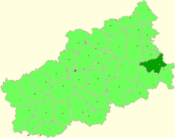
Kashinsky District
| Kashinsky District Кашинский район (Russian) |
|
|---|---|
 Location of Kashinsky District in Tver Oblast |
|
| Coordinates: 57°21′N 37°37′E / 57.350°N 37.617°ECoordinates: 57°21′N 37°37′E / 57.350°N 37.617°E | |
|
|
|
| Location | |
| Country | Russia |
| Federal subject | Tver Oblast |
| Administrative structure (as of 2012) | |
| Administrative center | town of Kashin |
| Administrative divisions: | |
| Urban settlements | 1 |
| Rural settlements | 11 |
| Inhabited localities: | |
| Cities/towns | 1 |
| Rural localities | 396 |
| Municipal structure (as of April 2009) | |
| Municipally incorporated as | Kashinsky Municipal District |
| Municipal divisions: | |
| Urban settlements | 1 |
| Rural settlements | 11 |
| Statistics | |
| Area | 2,010 km2 (780 sq mi) |
| Population (2010 Census) | 27,410 inhabitants |
| • Urban | 59.0% |
| • Rural | 41.0% |
| Density | 13.64/km2 (35.3/sq mi) |
| Time zone | MSK (UTC+03:00) |
| Official website | |
| on | |
Kashinsky District (Russian: Ка́шинский райо́н) is an administrative and municipal district (raion), one of the thirty-six in Tver Oblast, Russia. It is located in the east of the oblast and borders with Kesovogorsky District in the north, Uglichsky District of Yaroslavl Oblast in the east, Kalyazinsky District in the southeast, Kimrsky District in the south, Rameshkovsky District in the west, and with Bezhetsky District in the northwest. The area of the district is 2,010 square kilometers (780 sq mi). Its administrative center is the town of Kashin. Population: 27,410 (2010 Census);12,701 (2002 Census);15,805 (1989 Census). The population of Kashin accounts for 59.0% of the district's total population.
The whole area of the district belongs to the drainage basin of the Volga River. The Volga, built as the Uglich Reservoir, makes the southeastern border of the district. The largest tributaries of the Volga within the district are the Medveditsa River, which crosses the southern part of the district and also makes the stretch of the border with Kimrsky District, and the Kashinka River.
...
Wikipedia

