Karnobat
|
Karnobat Карнобат |
|
|---|---|

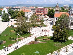
A view of central Karnobat
|
|
| Location of Karnobat | |
| Coordinates: 42°38′N 26°59′E / 42.633°N 26.983°ECoordinates: 42°38′N 26°59′E / 42.633°N 26.983°E | |
| Country | Bulgaria |
|
Province (Oblast) |
Burgas |
| Government | |
| • Mayor | Georgi Dimitrov |
| Elevation | 262 m (860 ft) |
| Population (December 2009) | |
| • City | 18,480 |
| • Urban | 25,592 |
| Time zone | EET (UTC+2) |
| • Summer (DST) | EEST (UTC+3) |
Karnobat (Bulgarian: Карнобат) is a town in the Burgas Province, Southeastern Bulgaria. It is the administrative centre of the homonymous Karnobat Municipality. As of December 2009, the town has a population of 18,480 inhabitants.
Karnobat municipality is situated in the south-eastern part of Bulgaria, and it falls within the administrative boundaries of Burgas region. Rishki Passage links the municipality to north Bulgaria. The Karnobat-Aitos range of the Balkan Mountains is located in the northern part of the municipality. Hisar Hill raise to the south of the town of Karnobat. The territory of Karnobat municipality is 806 km2 (311 sq mi), 87.37% of which is agricultural land, 9.81% forest land and 2.82% residential areas.
The Karnobat region, located in front of the south approaches of the Rishki and Varbishki passes, features an ancient history, dating back to the Neolithic era. Villages and tumuli reveal traces of life from the Neolithic and the Iron Age, rich settlement life during the antiquity and Middle Ages.
The first information for Karnobat was written in 1153 and included in The Geography by Muhammad al-Idrisi— Arabic traveller and scientist. The historical sources show that since the 19th century up to present days the town has always been an administrative, economic and commercial centre with a traditional yearly fair.
The town of Karnobat was mentioned under different names in the documents from the Turkish registers and travel notes: Karinovassa. Karinabad, Karnovo...
After the foundation of the Bulgarian state in 681, because of its exceptional role, the lands of the Karnobat region were field of many battles between Bulgaria and Byzantium. Markeli fortress, a south Episcopal and military center, located 7.5 km west of Karnobat, has been the most significant place of interest since the times of the First Bulgarian Kingdom. During the Ottoman rules, the town was an important administrative and trade center included in the Silistra district. The fact that the Bulgarian priest Stoiko Vladislavov (known as Sofronii Vrachanski, one of the prominent men of the Bulgarian national revival) performed the service in Karnobat parish is indicative of the revival processes that took place in the region from 1791 to 1792.
...
Wikipedia

