Kaoping River
| Gaoping River (高屏溪) | |
|
Shimo-Tansui Railway Bridge (Old Kaoping River Iron Bridge) across the lower Gaoping River
|
|
| Country | Taiwan |
|---|---|
| Source | Yushan |
| - elevation | 3,400 m (11,155 ft) |
| - coordinates | 23°28′29″N 120°02′15″E / 23.47472°N 120.03750°E |
| Mouth | Taiwan Strait |
| - location | Linyuan District, Kaohsiung City |
| - elevation | 0 m (0 ft) |
| - coordinates | 22°28′59″N 120°34′47″E / 22.48306°N 120.57972°ECoordinates: 22°28′59″N 120°34′47″E / 22.48306°N 120.57972°E |
| Length | 171 km (106 mi) |
| Basin | 3,257 km2 (1,258 sq mi) |
| Discharge | for Liling Bridge (daily means) |
| - average | 268 m3/s (9,464 cu ft/s) |
| - max | 15,251 m3/s (538,584 cu ft/s) |
| - min | 9 m3/s (318 cu ft/s) |
|
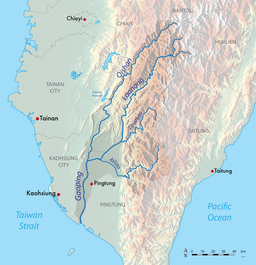
Location of the Gaoping River basin in southern Taiwan
|
|
The Gaoping River, also spelled Kaoping River (Chinese: 高屏溪; pinyin: Gāopíng Xī; Wade–Giles: Kao1-p'ing2 Hsi1), is a major river of southern Taiwan, flowing through Pingtung County and Kaohsiung City. It is the largest river in Taiwan by drainage area. The river is 171 kilometres (106 mi) long, draining a rugged area on the western side of the Central Mountain Range.
The Gaoping River headwaters originate near Yushan in northern Kaohsiung’s Tauyuan District and a small part of southern Nantou County. The upper section of the river, known as the Laonong, flows through a series of rugged canyons, through Liouguei and Gaoshu, and is joined by the Zhuokou River. The Laonong emerges from the mountains at Meinong as a wide braided stream and after being joined by the Ailiao from the east, the Gaoping proper is formed, which flows about 50 kilometres (31 mi) south along the coastal plain, through Pingtung County, emptying into the Taiwan Strait in Linyuan District. The Qishan River and the Wuluo River flow into the lower section of the Gaoping from north and east, respectively.
...
Wikipedia


