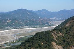
Laonong River
| Laonong River | |
|---|---|
 |
|
|
Map showing the mouth of Laonong River at its confluence with the Ailiao River
|
|
| Country | Taiwan |
| Basin | |
| Main source |
Central Mountain Range: Yushan 3,952 m (12,966 ft) 23°28′12″N 120°57′26″E / 23.4700°N 120.95717°E |
| River mouth |
Liouguei 22°47′49″N 120°30′42″E / 22.7969°N 120.5117°ECoordinates: 22°47′49″N 120°30′42″E / 22.7969°N 120.5117°E |
| River system | Gaoping River |
| Basin size | 1,372 km2 (530 sq mi) |
| Physical characteristics | |
| Length | 136 km (85 mi) |
| Discharge |
|
The Laonong River, also spelled Laonung River (Chinese: 荖濃溪; pinyin: Lǎo nóng xī; Wade–Giles: Lao3-nung2 Hsi1), is a tributary of the Gaoping River in Taiwan; it is the main course of the river system above the Gaoping River. It flows through Kaohsiung City for 136 km.
...
Wikipedia

