Kansas City Missouri
| Kansas City, Missouri | |||
|---|---|---|---|
| City | |||
| City of Kansas City | |||

From top left: Downtown Kansas City from Liberty Memorial, Crown Center at Christmas, KC Streetcar, Washington Square Park, Union Station lit blue for the World Series, the Thinker at the Nelson-Atkins Museum of Art, Liberty Memorial, and the Library area of Downtown.
|
|||
|
|||
| Nickname(s): "KC", "KCMO", the "City of Fountains", or the "Heart of America" | |||
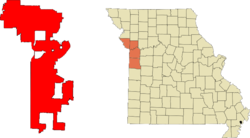
 Location in Jackson, Clay, Platte, and Cass counties in the state of Missouri. |
|||
| Location in the United States | |||
| Coordinates: 39°05′59″N 94°34′42″W / 39.09972°N 94.57833°WCoordinates: 39°05′59″N 94°34′42″W / 39.09972°N 94.57833°W | |||
| Country | United States | ||
| State | Missouri | ||
| Counties | Jackson, Clay, Platte, Cass | ||
| Incorporated | June 1, 1850 (as the Town of Kansas); March 28, 1853 (as the City of Kansas) | ||
| Government | |||
| • Mayor | Sly James (I) | ||
| Area | |||
| • City | 319.03 sq mi (826.28 km2) | ||
| • Land | 314.95 sq mi (815.72 km2) | ||
| • Water | 4.08 sq mi (10.57 km2) | ||
| • Urban | 584.4 sq mi (1,513.59 km2) | ||
| • Metro | 7,952 sq mi (20,596 km2) | ||
| Elevation | 910 ft (277 m) | ||
| Population (2010) | |||
| • City | 459,787 | ||
| • Estimate (2016) | 481,420 | ||
| • Rank | US: 37th MO: 1st |
||
| • Density | 1,400/sq mi (560/km2) | ||
| • Urban | 1,519,417 (US: 31st) | ||
| • Metro | 2,159,159 (US: 29th) | ||
| • CSA | 2,428,362 (US: 24th) | ||
| Demonym(s) | Kansas Citian | ||
| Time zone | CST (UTC−6) | ||
| • Summer (DST) | CDT (UTC−5) | ||
| ZIP Codes | 64101-64102, 64105-64106, 64108-64114, 64116-64121, 64123-64134, 64136-64139, 64141, 64144-64149, 64151-64158, 64161, 64163-64168, 64170-64172, 64179-64180, 64183-64184, 64187-64188, 64190-64193, 64195-64199, 64999 | ||
| Area code(s) | 816, 975 (planned) | ||
| FIPS code | 29000-38000 | ||
| GNIS feature ID | 0748198 | ||
| Interstates |
|
||
| Airports | Kansas City International Airport | ||
| Website | KCMO.org | ||
Kansas City is the largest city in Missouri, United States. According to the U.S. Census Bureau, the city had an estimated population of 481,420 in 2016, making it the 37th largest city by population in the United States. It is the central city of the Kansas City metropolitan area, which straddles the Kansas–Missouri border. Kansas City was founded in the 1830s as a Missouri River port at its confluence with the Kansas River coming in from the west. On June 1, 1850 the town of Kansas was incorporated; shortly after came the establishment of the Kansas Territory. Confusion between the two ensued and the name Kansas City was assigned to distinguish them soon thereafter.
Sitting on Missouri's western border, with Downtown near the confluence of the Kansas and Missouri rivers, the modern city encompasses some 319.03 square miles (826.3 km2), making it the 23rd largest city by total area in the United States. Most of the city lies within Jackson County, but portions spill into Clay, Cass, and Platte counties. Along with Independence, it serves as one of the two county seats for Jackson County. Major suburbs include the Missouri cities of Independence and Lee's Summit and the Kansas cities of Overland Park, Olathe, and Kansas City.
The city is composed of several neighborhoods, including the River Market District in the north, the 18th and Vine District in the east, and the Country Club Plaza in the south. Kansas City is also known for its cuisine (including its distinctive style of barbecue) and its craft breweries.
...
Wikipedia


