Kankakee, Illinois
|
Kankakee, Illinois Theakake |
|
|---|---|
| City | |
| City of Kankakee | |

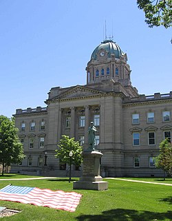
Kankakee County Courthouse, in Kankakee, Illinois
|
|
| Location of Kankakee within Illinois | |
| Coordinates: 41°7′12″N 87°51′40″W / 41.12000°N 87.86111°WCoordinates: 41°7′12″N 87°51′40″W / 41.12000°N 87.86111°W | |
| Country | United States |
| State | |
| County | Kankakee |
| Established | 1853 |
| Incorporated (city) | 1865 |
| Government | |
| • Type | Mayor-Council |
| • Mayor | Nina Epstein (R) |
| • City Council | 14 aldermen |
| Area | |
| • Total | 14.62 sq mi (37.9 km2) |
| • Land | 14.14 sq mi (36.6 km2) |
| • Water | 0.480 sq mi (1.24 km2) |
| Elevation | 656 ft (200 m) |
| Population (2010) | |
| • Total | 27,537 |
| • Estimate (2012) | 27,349 |
| • Density | 1,900/sq mi (730/km2) |
| Demonym(s) | Kankakeean |
| Time zone | CST (UTC-6) |
| • Summer (DST) | CDT (UTC-5) |
| ZIP codes | 60901 |
| Area code(s) | 815, 779 |
| FIPS code | 17-38934 |
| GNIS feature ID | 411300 |
| Website | www |
Kankakee /kæŋkəˈki/ is a city in and the county seat of Kankakee County, Illinois, United States. The city's name is probably derived from the Miami-Illinois word teeyaahkiki, meaning: "Open country/exposed land/land in open/land exposed to view," in reference to the area's prior status as a marsh. As of the 2010 census, the city population was 27,537. Kankakee is a principal city of the Kankakee-Bourbonnais-Bradley Metropolitan Statistical Area and the Chicago–Naperville–Michigan City, IL-IN-WI Combined Statistical Area, which includes all of Kankakee County.
The area of Kankakee was inhabited by the Potawatami beginning sometime in the 18th century. In 1833 the Potawatami signed a treaty with the United States government, agreeing to leave the region and move west. Kankakee was founded in 1854.
Kankakee is located at 41°7′12″N 87°51′36″W / 41.12000°N 87.86000°W (41.12, −87.86).
...
Wikipedia

