Kandhamal district
|
Kandhamal କନ୍ଧମାଳ ଜିଲ୍ଲା Phulabani (ଫୁଲବାଣୀ) |
|
|---|---|
| District | |

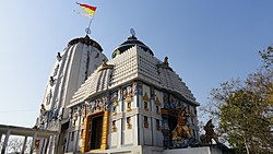
Jagannath temple in Phulbani, the headquarters of Kandhamal
|
|
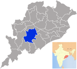
 Location in Odisha, India |
|
| Coordinates: 20°28′N 84°14′E / 20.47°N 84.23°ECoordinates: 20°28′N 84°14′E / 20.47°N 84.23°E | |
| Country |
|
| State | Odisha |
| Headquarters | Phulbani |
| Government | |
| • Collector | Raghu G |
| • Member of Lok Sabha | Pratyusha Rajeshwari Singh, BJD |
| Area | |
| • Total | 8,021 km2 (3,097 sq mi) |
| Elevation | 700 m (2,300 ft) |
| Population (2011) | |
| • Total | 731,952 |
| • Density | 91/km2 (240/sq mi) |
| Languages | |
| • Official | Odia, English |
| Time zone | IST (UTC+5:30) |
| PIN | 762 0xx |
| Vehicle registration | OD-12 |
| Sex ratio | 0.964 ♂/♀ |
| Literacy | 65.12% |
| Lok Sabha constituency | Kandhamal |
| Vidhan Sabha constituency | 3, 102- Balliguda (S.T.), 103- G. Udayagiri (S.T), 104- Phulbani (S.C.) |
| Climate | Aw (Köppen) |
| Precipitation | 1,587 millimetres (62.5 in) |
| Avg. summer temperature | 40 °C (104 °F) |
| Avg. winter temperature | 5 °C (41 °F) |
| Website | www |
Kandhamal(Odia: କନ୍ଧମାଳ ଜିଲ୍ଲା) is a district of the state of Odisha, India. The district headquarters of the district is Phulbani.
The Kandhmal district was created on 1 January 1994 from the former Boudh-Kandhmal district as a result of district reorganization in the state of Odisha. Before that the district was known as Phulbani.
The district lies between 83.30° E to 84-48° E longitude and 19-34° N to 20-54° latitude. The district headquarters is Phulbani, located in the central part of the district. The other popular locations are Baliguda, G. Udayagiri, Tikabali and Raikia.
The territory is rural, with scenic beauty such as waterfalls and springs, and also has a number of historical antiquities.
A majority of the land area of the district (71%) is forests, and 12% of the land is cultivable. The connectivity with other districts is poor. Kandhamal is one of the poorest districts in Orissa, ranking 29th out of 30 districts by the Human Development Index.
According to the 2011 census Kandhamal district has a population of 731,952, roughly equal to the nation of Guyana or the US state of Alaska. This gives it a ranking of 497th in India (out of a total of 640). The district has a population density of 91 inhabitants per square kilometre (240/sq mi). Its population growth rate over the decade 2001-2011 was 12.92%. Kandhamal has a sex ratio of 1037 females for every 1000 males, and a literacy rate of 65.12%.
Most inhabitants belong to the Kandha (Khonds) tribes, who are said to be "proud and aggressive" in the words of a district official. They hold 77% of the cultivable land. About 17% of the population are Panas who are designated as Scheduled Castes. They hold 9% of the cultivable land. The majority of the Panas (90%) are Christian. Frequest clashes occur between the Kandhas and the Panas and, since 2000, the clashes took on a religious aspect, leading to massive riots in August-September 2008.
...
Wikipedia
