Kalat State
| Khanate of Kalat | ||||||||||
| خانات ءِ قلات | ||||||||||
|
||||||||||
|
Flag
|
||||||||||
|
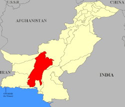
Map of Pakistan with Kalat highlighted
|
||||||||||
| Capital | Kalat | |||||||||
| Languages | Persian, Brahui | |||||||||
| Government |
Monarchy Princely state |
|||||||||
| History | ||||||||||
| • | Established | 1666 | ||||||||
| • | Disestablished | 14 October 1955 | ||||||||
| Area | 91,909 km2 (35,486 sq mi) | |||||||||
|
||||||||||
| Today part of | Balochistan, Pakistan | |||||||||
| Government of Balochistan | ||||||||||
| Warning: Value not specified for "" | ||||||||||
The Khanate of Kalat (Balochi: خانات ءِ قلات) was a princely state that existed from 1666 to 1955 in the centre of the modern-day province of Balochistan, Pakistan. Prior to that they were subjects of Mughal emperor Akbar. Ahmedzai Brahui Khan ruled the state independently until 1839, when it became a self-governing state in a subsidiary alliance with British India. After the signature of the Treaty of Mastung by the Khan of Kalat and the Baloch Sardars in 1876, Kalat became part of the Baluchistan Agency. It was briefly independent from August 1947 till March 1948, when its Khan acceded his state to the new Dominion of Pakistan. It remained a princely state of Pakistan until 1955, when it was incorporated into the country.
The Khanate of Kalat occupied the central part of the territory of modern-day Balochistan province in Pakistan. To the north was Baluchistan (Chief Commissioner's Province).
The principal mountains are the Central Baloch, Kirthar, Pab, Siahan, Central Makran and Makran Coast Ranges, which descend in elevation from about 10,000 to 1,200 feet (370 m). The drainage of the country is almost all carried off to the south by the Nari, Mula, Hab, Porali, Hingol and Dasht rivers. The only large river draining northwards is the Rakhshan. The coast line includes Gawadar, Pasni, Sonmiani and Geewani, modern-day Pakistani Balochistan.
A ethnic Brahui sub division of kalat headed by chief nawab of zarakzai tribe called chief of jhalawan
...
Wikipedia


