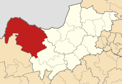
Kagisano-Molopo Local Municipality
| Kagisano/Molopo | |
|---|---|
| Local municipality | |
 Location in the North West |
|
| Coordinates: 26°S 24°E / 26°S 24°ECoordinates: 26°S 24°E / 26°S 24°E | |
| Country | South Africa |
| Province | North West |
| District | Dr Ruth Segomotsi Mompati |
| Seat | Ganyesa |
| Wards | 15 |
| Government | |
| • Type | Municipal council |
| • Mayor | Ontlametse Mochware (ANC) |
| Area | |
| • Total | 23,827 km2 (9,200 sq mi) |
| Population (2011) | |
| • Total | 105,789 |
| • Density | 4.4/km2 (11/sq mi) |
| Racial makeup (2011) | |
| • Black African | 96.0% |
| • Coloured | 1.4% |
| • Indian/Asian | 0.2% |
| • White | 2.1% |
| First languages (2011) | |
| • Tswana | 90.3% |
| • Afrikaans | 3.4% |
| • English | 1.6% |
| • Other | 4.7% |
| Time zone | SAST (UTC+2) |
| Municipal code | NW397 |
Kagisano-Molopo Local Municipality is a local municipality in the Dr Ruth Segomotsi Mompati District Municipality, in the North West province of South Africa. It was created at the local government elections of 18 May 2011 by merging the Kagisano and Molopo municipalities.
Kagisano-Molopo covers an area of 23,827 square kilometres (9,200 sq mi) in the north-western corner of the North West province. It borders on the Kgalagadi District of the Republic of Botswana to the north, Moshaweng Local Municipality in the Northern Cape province to the south-west, Greater Taung Local Municipality to the south, Naledi Local Municipality to the south-east, and Ratlou Local Municipality to the east. The main towns in the municipality are Ganyesa, Pomfret, Morokweng and Piet Plessis.
According to the 2011 census, the municipality has a population of 105,789. The majority of this population, 96.0%, described themselves as "Black African"; there are small minorities of those who describe themselves as "White" (2.1%) and "Coloured" (1.4%). 90.3% of the population speak Setswana as a first language, while 3.4% speak Afrikaans and 1.6% speak English.
...
Wikipedia
