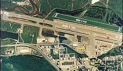
Juneau International Airport
| Juneau International Airport | |||||||||||||||
|---|---|---|---|---|---|---|---|---|---|---|---|---|---|---|---|
 |
|||||||||||||||
| Summary | |||||||||||||||
| Airport type | Public | ||||||||||||||
| Owner | City of Juneau | ||||||||||||||
| Serves | Juneau, Alaska | ||||||||||||||
| Hub for | Wings of Alaska | ||||||||||||||
| Elevation AMSL | 25 ft / 8 m | ||||||||||||||
| Coordinates | 58°21′18″N 134°34′35″W / 58.35500°N 134.57639°WCoordinates: 58°21′18″N 134°34′35″W / 58.35500°N 134.57639°W | ||||||||||||||
| Website | Juneau |
||||||||||||||
| Map | |||||||||||||||
| Location of airport in Alaska | |||||||||||||||
| Runways | |||||||||||||||
|
|||||||||||||||
| Statistics (2013) | |||||||||||||||
|
|||||||||||||||
|
Source: Federal Aviation Administration
|
|||||||||||||||
| Aircraft operations | 90,268 |
|---|---|
| Based aircraft | 325 |
Juneau International Airport (IATA: JNU, ICAO: PAJN, FAA LID: JNU) is a city owned, public use airport and seaplane base located seven nautical miles (8 mi, 13 km) northwest of the central business district of Juneau, a city and borough in the U.S. state of Alaska which has no direct road access to the outside world. The airport serves as a regional hub for all air travel, from bush carriers to a major U.S. air carrier, Alaska Airlines. Another major air carrier, Delta Air Lines, also operates flights with mainline jet aircraft from the airport although this service is seasonal in nature.
The National Plan of Integrated Airport Systems for 2015-2019 categorized it as a primary commercial service (nonhub) airport based on 353,048 enplanements (boardings) in 2012. As per the Federal Aviation Administration, this airport had 378,741 passenger enplanements in calendar year 2008, 337,038 in 2009, and 344,057 in 2010.
During World War II, Juneau Airport was used by the United States Army Air Forces as a transport link between the combat bases being established in the Aleutians and airfields in the Continental United States. It was also used by Air Transport Command and facilitated the transport of Lend-Lease aircraft to the Soviet Union via Nome (Marks Army Airfield).
...
Wikipedia

