Joinville Battalion
| Joinville-le-Pont | ||
|---|---|---|
| Commune | ||

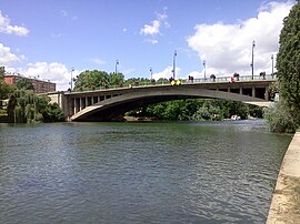
The bridge of Joinville-le-Pont
|
||
|
||
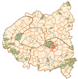
 Paris and inner ring departments |
||
| Coordinates: 48°49′17″N 2°28′22″E / 48.8214°N 2.4728°ECoordinates: 48°49′17″N 2°28′22″E / 48.8214°N 2.4728°E | ||
| Country | France | |
| Region | Île-de-France | |
| Department | Val-de-Marne | |
| Arrondissement | Nogent-sur-Marne | |
| Canton | Charenton-le-Pont | |
| Government | ||
| • Mayor (2008–) | Olivier Dosne | |
| Area1 | 2.42 km2 (0.93 sq mi) | |
| Population (2006)2 | 17,420 | |
| • Density | 7,200/km2 (19,000/sq mi) | |
| Time zone | CET (UTC+1) | |
| • Summer (DST) | CEST (UTC+2) | |
| INSEE/Postal code | 94042 /94340 | |
|
1 French Land Register data, which excludes lakes, ponds, glaciers > 1 km² (0.386 sq mi or 247 acres) and river estuaries. 2Population without double counting: residents of multiple communes (e.g., students and military personnel) only counted once. |
||
1 French Land Register data, which excludes lakes, ponds, glaciers > 1 km² (0.386 sq mi or 247 acres) and river estuaries.
Joinville-le-Pont is a commune in the southeastern suburbs of Paris, France. It is located 9.4 km (5.8 mi) from the center of Paris.
The commune was created in 1791 under the name La Branche-du-Pont-de-Saint-Maur (literally "The Branch of Saint-Maur's Bridge") by detaching its territory from the commune of Saint-Maur-des-Fossés. The commune was renamed Joinville-le-Pont (literally "Joinville the Bridge") on 29 August 1831. Under Louis-Philippe of France, the Redoute de Gravelle was built in the commune.
In 1929, the commune of Joinville-le-Pont lost more than a third of its territory when the city of Paris annexed the Bois de Vincennes, a part of which belonged to Joinville-le-Pont.
Joinville-le-Pont is served by Joinville-le-Pont station on Paris RER line A.
Public schools include:
There is a private school, Groupe Scolaire A.P.E.P., which runs from preschool to senior high school/sixth-form college (lycée).
...
Wikipedia

