Johnson City, Texas
| Johnson City, Texas | |
|---|---|
| City | |

Blanco County Courthouse
|
|
| Motto: "The Crossroads Of The Texas Hill Country" | |
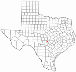
 Location of Johnson City, Texas |
|
 |
|
| Coordinates: 30°16′35″N 98°24′29″W / 30.27639°N 98.40806°WCoordinates: 30°16′35″N 98°24′29″W / 30.27639°N 98.40806°W | |
| Country | United States |
| State | Texas |
| County | Blanco |
| Area | |
| • Total | 1.7 sq mi (4.5 km2) |
| • Land | 1.7 sq mi (4.5 km2) |
| • Water | 0.0 sq mi (0.0 km2) |
| Elevation | 1,198 ft (365 m) |
| Population (2010) | |
| • Total | 1,656 |
| • Density | 946/sq mi (365.2/km2) |
| Time zone | Central (CST) (UTC-6) |
| • Summer (DST) | CDT (UTC-5) |
| ZIP code | 78636 |
| Area code(s) | 830 |
| FIPS code | 48-37780 |
| GNIS feature ID | 1338790 |
| Website | www |
Johnson City is a city in Blanco County, Texas, United States. The population was 1,656 at the 2010 census. It is the county seat of Blanco County.
Johnson City was the hometown of President Lyndon Johnson and was founded by James Polk Johnson, nephew of Samuel Ealy Johnson, Sr. and uncle to President Johnson. James Polk Johnson donated a 320-acre (130 ha) site on the Pedernales River for the founding of the town in 1879. The county seat of Blanco County was moved to Johnson City in 1890.
Johnson City is located in central Blanco County at 30°16′35″N 98°24′29″W / 30.276427°N 98.408105°W, about 1 mile (2 km) south of the Pedernales River. U.S. Routes 281 and 290 join near the center of town; US 281 leads north 23 miles (37 km) to Marble Falls, and US 290 leads west 30 miles (48 km) to Fredericksburg. The two highways run south out of town together; US 290 soon turns east and leads 47 miles (76 km) to Austin, while US 281 continues south 64 miles (103 km) to San Antonio.
According to the United States Census Bureau, Johnson City has a total area of 1.7 square miles (4.5 km2), all land.
Johnson City experiences a humid subtropical climate, with hot summers and a generally mild winter. Temperatures range from 82 °F (27.8 C) in the summer to 47 °F (8.3 C) during winter.
...
Wikipedia
