Joaquin, Texas
| Joaquin, Texas | |
|---|---|
| City | |
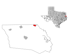
 Location of Joaquin, Texas |
|
 |
|
| Coordinates: 31°57′56″N 94°2′54″W / 31.96556°N 94.04833°WCoordinates: 31°57′56″N 94°2′54″W / 31.96556°N 94.04833°W | |
| Country | United States |
| State | Texas |
| County | Shelby |
| Area | |
| • Total | 2.3 sq mi (6.0 km2) |
| • Land | 2.3 sq mi (6.0 km2) |
| • Water | 0.0 sq mi (0.0 km2) |
| Elevation | 226 ft (69 m) |
| Population (2010) | |
| • Total | 824 |
| • Density | 360/sq mi (140/km2) |
| Time zone | Central (CST) (UTC-6) |
| • Summer (DST) | CDT (UTC-5) |
| ZIP code | 75954 |
| Area code(s) | 936 |
| FIPS code | 48-37684 |
| GNIS feature ID | 1360274 |
Joaquin (/wɔːˈkiːn/ wah-KEEN) is a city in northeastern Shelby County, Texas, United States. The population was 824 at the 2010 census. It is located on U.S. Highway 84 (future Interstate 69) and the tracks of the Southern Pacific Railroad.
Joaquin is located at 31°57′56″N 94°2′54″W / 31.96556°N 94.04833°W (31.965511, -94.048316).
According to the United States Census Bureau, the city has a total area of 2.3 square miles (6.0 km²), of which, 2.3 square miles (6.0 km²) of it is land and 0.43% is water.
The site was founded in 1885 for a station for the Houston, East and West Texas Railway. The land was donated by Benjamin Franklin Morris, and the site was named for his grandson Joaquin. The post office was opened in the following year. The site operated as a shipping point for cotton and lumber, with a lumber mill functioning there. The town was incorporated in 1940, with a population increase with the development of the Toledo Bend Reservoir years later.
...
Wikipedia
