Jhanjharpur
| Jhanjharpur | |
|---|---|
| Town | |

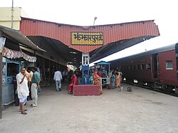
Jhanjharpur Railway Station
|
|
| Location in Bihar, India | |
| Coordinates: 26°16′N 86°17′E / 26.27°N 86.28°ECoordinates: 26°16′N 86°17′E / 26.27°N 86.28°E | |
| Country |
|
| State | Bihar |
| District | Madhubani |
| Elevation | 59 m (194 ft) |
| Population (2001) | |
| • Total | 24,102 |
| Languages | |
| • Official | Maithili, Urdu and Hindi |
| Time zone | IST (UTC+5:30) |
| Lok Sabha constituency | Jhanjharpur |
| Vidhan Sabha constituency | Jhanjharpur |
Jhanjharpur is a town and headquarters of a sub-division in the Madhubani district of the state of Bihar, India.
Jhanjharpur is located in the foothills of the Himalayas, on the bank of the Kamala River. The river is formed from the confluence of two separate rivers, the Kamla and the Balan. The topography of this place is beautiful and the land is immensely fertile, which is the reason it is still surviving without any financial and economic structure. It is located on the foothills of the Himalayas, the impact is visible in its climate. If you walk straight from this place towards north on the globe, you will reach Mt. Everest. The place receives plenty of rainfall due to its geographical position.
The language spoken in this region is Maithili hence the people are called maithil (after the language) the famous festival of this region is janki naumi and mahadev puja.
Kanhauli,Sarisab, Sarbasima, Naruar, Mahrail, Mohna, Majhoura, Simra, Sukhet, Lalgang, kuchbi, and the catchment villages of this region have been the land of great thinkers of the nyaya and other philosophical traditions in Indian philosophy.
As of 2011 India census, Jhanjharpur had a population of 24112. Males constitute 52% of the population and females 48%. Jhanjharpur has an average literacy rate of 47.97%, which is less than the national average of 59.5%: male literacy is 60.97%. and, female literacy is 34.05%.There are many lingual minorities which have contributed to the development of Jhanjharpur.
Patna has a humid subtropical climate with hot summers from late March to early June, the monsoon season from late June to late September and a mild winter from November to February.Highest temperature ever recorded is 46.6 °C(In,1966), lowest ever is 2.3 °C(In,2003) and highest rainfall was 204.5 mm(In,1997). The table below details historical monthly averages for climate variables.
Nearest Airport is Jaiprakash Narayan International Airport at Patna, 180 km from here. Jhanjharpur is located on NH 57 and 40 km from Darbhanga. On India Railways map, Jhanjharpur is a junction having meter gauge services to Sakri, Nirmali and Lukaha. Sakri is well connected on rail network through Broad Gauge line.
Jhanjharpur has good educational background. This part of land have produced many engineers, doctors, bankers, IAS, IFS etc.
...
Wikipedia

