Jamesport, New York
| Jamesport, New York | |
|---|---|
| Hamlet and census-designated place | |

Jamesport, New York
|
|
 |
|
| Coordinates: 40°56′40″N 72°34′38″W / 40.94444°N 72.57722°WCoordinates: 40°56′40″N 72°34′38″W / 40.94444°N 72.57722°W | |
| Country | United States |
| State | New York |
| County | Suffolk |
| Town | Riverhead |
| Area | |
| • Total | 4.5 sq mi (11.7 km2) |
| • Land | 4.5 sq mi (11.6 km2) |
| • Water | 0.04 sq mi (0.1 km2) |
| Elevation | 16 ft (5 m) |
| Population (2010) | |
| • Total | 1,710 |
| • Density | 380/sq mi (150/km2) |
| Time zone | Eastern (EST) (UTC-5) |
| • Summer (DST) | EDT (UTC-4) |
| ZIP code | 11947 |
| Area code(s) | 631 |
| FIPS code | 36-38253 |
| GNIS feature ID | 0953924 |
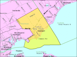
Jamesport is a census-designated place (CDP) that roughly corresponds to the hamlet by the same name in the Town of Riverhead in Suffolk County, New York, United States. The CDP's population was 1,710 at the 2010 census.
Jamesport is known for its quaint downtown area including antique shops and a handful of fine restaurants. The population of the hamlet grows considerably during the summer months due to the influx of day-tourists and vacationers taking advantage of the Great Peconic Bay beaches located on the south side of the hamlet. During the late summer/fall months, the hamlet is busy once again, due to "pumpkin pickers", "wine tasters", and other tourists taking in the beautiful fall scenery Jamesport has to offer. Jamesport is home to many farms including sod, pumpkin, flower, potato and wineries. Jamesport State Park is located north of Jamesport in the adjacent hamlet of Northville. A 2010 park master plan called for it to be renamed the "Hallock State Park Preserve".
According to the United States Census Bureau, the CDP has a total area of 4.5 square miles (11.7 km2), of which 4.5 square miles (11.6 km2) is land and 0.039 square miles (0.1 km2), or 0.60%, is water.
The hamlet now called Jamesport was first settled in the 1690s and originally was called Aquebogue. It became Lower Aquebogue when another hamlet was established to the west called Upper Aquebogue. The Jamesport Meeting House, built in 1731, is the oldest operating church building in Suffolk County.
The name "Jamesport" refers to James Tuthill, who settled the area south of Lower Aquebogue on the Peconic Bay with his family in 1833. Over time Lower Aquebogue came to be called Jamesport, while the community 1 mile (2 km) to the south previously called Jamesport came to be called South Jamesport (and is included in the present-day Jamesport CDP). Upper Aquebogue became just Aquebogue.
...
Wikipedia

