Jackson Parish, Louisiana
| Jackson Parish, Louisiana | |
|---|---|

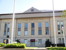
Jackson Parish Courthouse in Jonesboro
|
|
 Location in the U.S. state of Louisiana |
|
 Louisiana's location in the U.S. |
|
| Founded | 1845 |
| Named for | Andrew Jackson |
| Seat | Jonesboro |
| Largest town | Jonesboro |
| Area | |
| • Total | 580 sq mi (1,502 km2) |
| • Land | 569 sq mi (1,474 km2) |
| • Water | 11 sq mi (28 km2), 1.9% |
| Population (est.) | |
| • (2015) | 15,858 |
| • Density | 29/sq mi (11/km²) |
| Congressional district | 5th |
| Time zone | Central: UTC-6/-5 |
| Website | www |
Jackson Parish (French: Paroisse de Jackson) is a parish located in the U.S. state of Louisiana. As of the 2010 census, the population was 16,274. The parish seat is Jonesboro. The parish was formed in 1845 from parts of Claiborne, Ouachita, and Union Parishes.
East of Jonesboro is the Jimmie Davis State Park, which includes Caney Lake Reservoir.
Jackson Parish was founded in 1845 and named for President Andrew Jackson.
During the American Civil War Confederate General Richard Taylor sent five companies into Jackson and Winn parishes to arrest conscripts who failed to report for duty and to halt jayhawker groups in the area. General Edmund Kirby-Smith, moreover, directed that "all men who shirked their military duty be hunted down and forced into camp. Those who tried to escape the conscript hunters would be shot. The terrain of Louisiana with its many canebrakes, swamps, and hills in which to hide, made such an order difficult to carry out," explains the historian John D. Winters in The Civil War in Louisiana (1963).
According to the U.S. Census Bureau, the parish has a total area of 580 square miles (1,500 km2), of which 569 square miles (1,470 km2) is land and 11 square miles (28 km2) (1.9%) is water.
As of the census of 2000, there were 15,397 people, 6,086 households, and 4,302 families residing in the parish. The population density was 27 people per square mile (10/km²). There were 7,338 housing units at an average density of 13 per square mile (5/km²). The racial makeup of the parish was 71.01% White, 27.87% Black or African American, 0.29% Native American, 0.21% Asian, 0.01% Pacific Islander, 0.24% from other races, and 0.37% from two or more races. 0.61% of the population were Hispanic or Latino of any race.
...
Wikipedia
