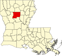
Winn Parish, Louisiana
| Winn Parish, Louisiana | |
|---|---|

Winn Parish Courthouse in Winnfield
|
|
 Location in the U.S. state of Louisiana |
|
 Louisiana's location in the U.S. |
|
| Founded | February 24, 1852 |
| Named for | Walter Winn or Winfield Scott |
| Seat | Winnfield |
| Largest city | Winnfield |
| Area | |
| • Total | 957 sq mi (2,479 km2) |
| • Land | 950 sq mi (2,460 km2) |
| • Water | 6.7 sq mi (17 km2), 0.7% |
| Population (est.) | |
| • (2015) | 14,568 |
| • Density | 16/sq mi (6/km²) |
| Congressional district | 5th |
| Time zone | Central: UTC-6/-5 |
Winn Parish (French: Paroisse de Winn) is a parish located in the U.S. state of Louisiana. As of the 2010 census, the population was 15,313. Its seat is Winnfield. The parish was founded in 1852. It is last in alphabetical order of Louisiana's sixty-four parishes.
Winn is separated from along U.S. Highway 71 by Saline Bayou, the first blackwater protected waterway in the American South.
Winn Parish was established in 1852 from lands which had belonged to the parishes of Catahoula, , and Rapides.
During the Civil War, David Pierson, a young attorney, was elected to represent the parish at the Secession Convention called in January 1861 in Baton Rouge by Governor Thomas Overton Moore. Pierson voted against secession and refused, along with several others, to change his "no" vote at the end of the process when asked to do so to make the final tally unanimous.
There was little military action in Winn Parish during the Civil War, but there was a problem with conscripts fleeing into the wooded areas to avoid military duty. The Confederate States Army defeated a Union detachment sent to destroy a salt works in the parish. Winn Parish contributed to the $80,000 raised to build fortifications on the nearby Red River.
...
Wikipedia
