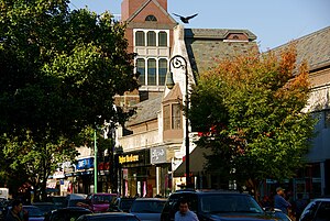
Jackson Heights, New York
| Jackson Heights | |
|---|---|
| Neighborhood of Queens | |

82nd Street in Jackson Heights
|
|
| Country |
|
| State |
|
| County | Queens |
| Population (2010) | |
| • Total | 108,152 |
| Ethnicity | |
| • White | 17.2% |
| • Asian | 22.0% |
| • African American | 2.0% |
| • Native American | 0.1% |
| • Hispanic | 56.5% |
| ZIP code | 11372 |
| Area code(s) | 718, 347, 917 |
|
Jackson Heights Historic District
|
|

Residential street in Jackson Heights
|
|
|
District position on New York City map
|
|
| Location | Bounded by Roosevelt Ave., Broadway, Leverich St., 70 St., Northern Blvd., and Junction Blvd., Queens, NYC |
|---|---|
| Coordinates | 40°45′5″N 73°53′13″W / 40.75139°N 73.88694°WCoordinates: 40°45′5″N 73°53′13″W / 40.75139°N 73.88694°W |
| Area | 300 acres (120 ha) |
| Architectural style | Late 19th and 20th Century Revivals |
| NRHP Reference # | 99000059 |
| Added to NRHP | January 27, 1999 |
Jackson Heights is a neighborhood in the northwestern portion of the borough of Queens in New York City. The neighborhood is part of Queens Community Board 3. Jackson Heights is neighbored by North Corona to the east, Elmhurst to the south, Woodside to the west, northern Astoria (Ditmars-Steinway) to the northwest, and East Elmhurst to the northeast. The main ZIP code of Jackson Heights is 11372. According to the 2010 United States Census, the neighborhood has a population of 108,152.
The Jackson Heights name comes from Jackson Avenue, the former name for Northern Boulevard, a major thoroughfare that bisects the neighborhood. John C. Jackson built the road across what is now Jackson Heights in 1859. The Jackson Avenue name is retained by this major road in a short stretch between Queens Plaza and Queens–Midtown Tunnel in Long Island City. The place was not particularly high, but the name "heights" showed that the place was originally meant to be exclusive. Until 1916, the area was called "Trains Meadow", but contrary to the name, there were very few trains in the area. It is suspected that it was corrupted from "".
The first land purchase of 128 acres (52 ha) was completed in 1910, and Edward A. MacDougall's Queensboro Corporation had bought about 325 acres (132 ha) by 1914. At first, the area could most easily be reached via a ferry from Manhattan or the Brooklyn bridges, but the Queensboro Bridge opened in 1909, followed by the elevated IRT Flushing Line—the present-day 7 train, just 20 minutes from Manhattan—came in 1917, and Fifth Avenue Coach Company double-decker coaches came in 1922.
...
Wikipedia


