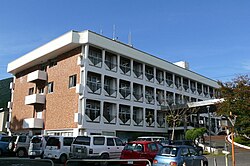
Izuhara, Nagasaki
|
Tsushima 対馬市 |
|||
|---|---|---|---|
| City | |||

Tsushima City Hall
|
|||
|
|||
 Location of Tsushima in Nagasaki Prefecture |
|||
| Location in Japan | |||
| Coordinates: 34°12′N 129°17′E / 34.200°N 129.283°ECoordinates: 34°12′N 129°17′E / 34.200°N 129.283°E | |||
| Country | Japan | ||
| Region | Kyushu | ||
| Prefecture | Nagasaki Prefecture | ||
| Government | |||
| • Mayor | Takarabe Yasunari | ||
| Area | |||
| • Total | 708.61 km2 (273.60 sq mi) | ||
| Population (March 31, 2017) | |||
| • Total | 31,550 | ||
| • Density | 45/km2 (120/sq mi) | ||
| Symbols | |||
| • Tree | Chionanthus retusus | ||
| • Flower | Azalea | ||
| • Bird | Ring-necked pheasant | ||
| Time zone | Japan Standard Time (UTC+9) | ||
| Website | www |
||
Tsushima (対馬市 Tsushima-shi) is a city located in Nagasaki Prefecture, Japan. It is the only city of Tsushima Subprefecture and it encompasses all of Tsushima Island Archipelago, which lies in the Tsushima Strait north of Nagasaki on the western side of Kyushu, the southernmost mainland island of Japan.
As of March 2017, the city has an estimated population of 31,550 and a population density of 45 persons per km2. Its total area is 708.61 km2, 17.3% of the area of Nagasaki Prefecture.
An Imperial decree in July 1899 established Izuhara, Sasuna and Shishimi as open ports for trading with the United States and the United Kingdom.
On April 1, 1975, Toyotama Village was promoted to the status of a town. Mine Village was also elevated to the status of a town in the following year.
The modern city of Tsushima was established on March 1, 2004, from the merger of six towns on Tsushima Island: Izuhara, Mitsushima and Toyotama (all from Shimoagata District), and Mine, Kamiagata and Kamitsushima (all from Kamiagata District). Both districts were dissolved as a result of this merger.
...
Wikipedia


